Issue
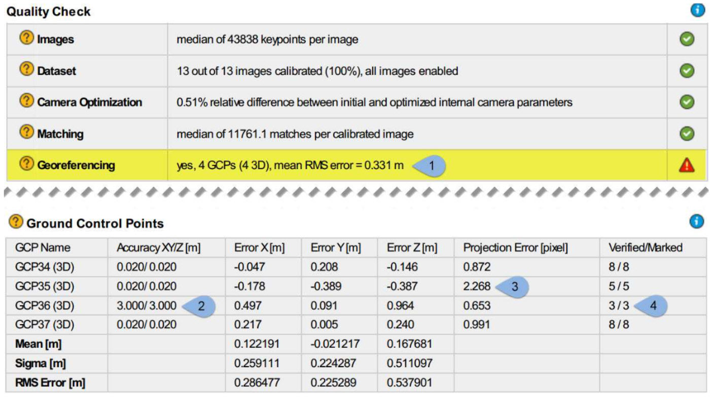
An error of the ground control points (GCPs) greater than 2 times the Ground Sampling Distance (GSD) may indicate that the GCPs were not correctly integrated into the dataset.
Indicators
When GCPs are used, and the mean RMS error is greater than 2 times the average GSD:
Causes
- Not enough GCPs were used, given the size of the project.
- Accuracy values for the GCPs are not properly set.
- Poor GCPs marking.
- GCPs are not marked on enough images.
Tip: The number assigned to each cause matches the number of the bullet points shown in the screenshot above in the indicators section.
Solutions
Possible solutions to the previously listed causes are proposed below.
For cause 1, not enough GCPs
- Add additional GCPs. A minimum number of 3 GCPs is required, but we recommend including at least 5 to 10 GCPs. When the topography of the area is complex, adding more GCPs could lead to a more accurate reconstruction.
For cause 2, not properly set accuracy values
- If the accuracy of the GCPs is known, then it should be entered instead of the default values in the GCP/MTP Manager.
- When using the default accuracy values in projects that are set to imperial (ft), then the GCP accuracy should be adjusted to 0.066.
For cause 3, poor GCPs marking
The quality of the GCPs marks can be estimated by reviewing the projection error for each GCP shown in the quality report (point 3 in the screenshot shown in the indicators section). All projection error values should be less than 1 pixel.
- If the values reported are greater than 1 pixel, then carefully remark the images.
For cause 4, GCPs not marked on enough images
- Add additional GCP marks on the project images. Each GCP should be marked in at least 2 images, but we recommend marking the GCPs on more project images.
Additionally
The linear rolling shutter distortion in the images can also cause high GCPs errors. In this case, we recommend to:
- Enable the linear shutter optimization in the Image Properties Editor.
- Capture the project area again while flying slower and/or at a higher altitude to reduce the amount of linear rolling shutter distortions that are present in your images. You can see how your camera and flight parameters influence the amount of linear rolling shutter distortion that is present in your images with Pix4D's vertical pixel displacement calculator.
Additional resources related to GCPs:
- Using GCPs
- Quality report specifications
- How are the GCP Errors defined in the Quality Report
- How to verify that the GCP Geolocation is correct