PIX4Dfields is an advanced agriculture mapping software for aerial crop analysis and digital farming. Capture high-resolution natural-color or multispectral imagery using any modern drone, including multi-rotors and fixed-wings, where and when you need it. PIX4Dfields provides easy access to a range of tools and capabilities for creating orthomosaics, vegetation indices, and annotations for statistical analysis. However, proper data acquisition is the foundation for generating quality outputs.
IN THIS ARTICLE
Choose your drone and camera
Plan a mission
Capture imagery
Visualize and analyze
Export and share
Choose your drone and camera
Both multi-rotor and fixed-wing drones, depending on project goals and constraints, are viable platforms. Considerations for the different platforms include survey area size, budget, and camera selection. The camera selection falls into two broad categories: RGB for natural-color orthomosaics, and multispectral for the generation of vegetation indices. PIX4Dfields can process datasets from the most common multispectral and RGB cameras available today. For more information about supported cameras: Supported cameras - PIX4Dfields
Plan a mission
PIX4Dfields requires careful consideration of flight planning parameters, regardless of the type of drone or camera, in order to acquire and process a good dataset. A failure to fly the drone properly may cause the outputs to be of substandard quality or cause processing to fail.
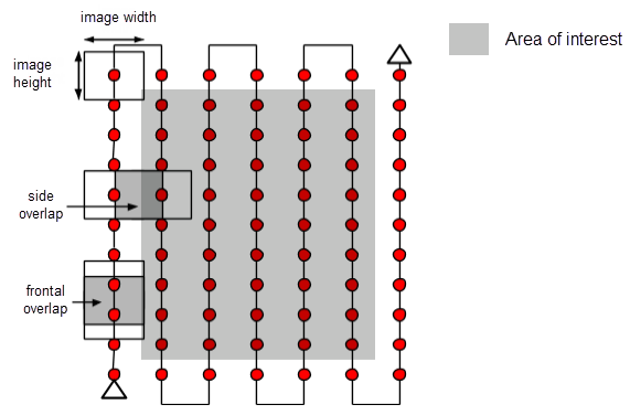
- Plan a grid flight with a minimum of 70-80% side, and 85% frontal overlap. Less overlap may cause processing to fail or create artifacts in the orthomosaic.
- Ensure the grid flight is bigger than the Area of interest.
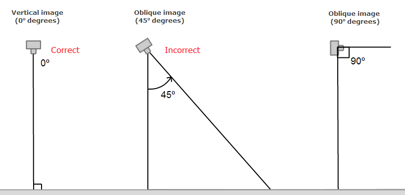
- Imagery must be nadir. A nadir image is an aerial photo taken vertically, or pointed straight down. If the camera is at an oblique angle then processing will fail. Some apps will set 00 as down and some will set 90 as down
- Use auto exposure.
- Acquire imagery at full resolution. Do not alter the aspect ratio as this reduces the amount of viable data, and can cause the camera to be unsupported.
- Consistent light. Full cloudy or full sunny conditions will create quality outputs. Intermittent sun and clouds may induce artifacts into the orthomosaics.
- Do not use Dewarping. If it's available, turn it off before capturing the images from the Remote Controller.
- When Dewarping is off, the images have a black vignette in the corners:

- When Dewarping is off, the images have a black vignette in the corners:
- Avoid using the "Elevation optimization" features, as they may result in the drone capturing non-nadir images toward the end of the flight. This can adversely affect the processing quality of the data.
- Avoid flying when the sun is near nadir (too high up) since it will introduce hot spots
- Flight lines should be perpendicular to the sun (if possible).
For more information:
Capture imagery
Once the flight parameters have been determined, a flight plan must be created and uploaded to the drone via a flight application. The application, typically an app on an iOS or Android device, will automate the drone flight according to the inputted flight parameters.
However, all of Pix4D's software is image acquisition app agnostic. PIX4Dfields can process images acquired from virtually any flight application as long as the images are of good quality and overlap. For more information on third-party flight apps: Which image acquisition app can I use with Pix4D's software?
After planning the mission, upload the flight plan to the drone, and let the automation fly the drone.
Download and process

Once the drone has landed, simply remove the SD card from the drone, create a project in PIX4Dfields, and import the images (.tiff or .jpg) or the folder with the images. Processing can begin immediately.

For more information on importing images: Image import and process steps - PIX4Dfields
For more information on processing options: Processing options - PIX4Dfields
If after processing, the orthomosaic has artifacts: Stitching artifacts - PIX4Dfields
If PIX4Dfields is giving Error R009: Error R0009 - PIX4Dfields
If PIX4Dfields is crashing while processing: PIX4Dfields crash troubleshooting
Visualize and analyze
After processing is complete, perform complex vegetation analysis using the predefined index templates, or create custom indices with the built-in index calculator. Create annotations for statistical calculations such as areas, lengths, and mean index values.
Export and share
Share your outputs with our Share to PIX4Dcloud for greater collaboration, or export your data to any farm management software, or third-party GIS software for further analysis.