The article provides definitions of the relative and absolute accuracy of a photogrammetric project. It also points out how using Ground Control Points or RTK/PPK drones increases the absolute accuracy of results.
The accuracy of the outputs can be distinguished into:
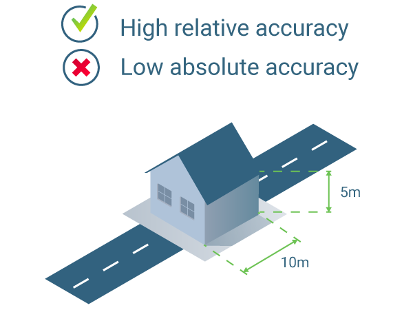
- Relative accuracy of a photogrammetric project is defined by comparing individual features on a map / reconstructed model / orthomosaic with other features on the same model. For example, the relative accuracy of the model is high if two points have the same distance between them on the model, and in reality.
- Absolute accuracy of a photogrammetric project is defined by the difference between the location of features on a map / reconstructed model / orthomosaic and their true position in a certain reference frame. For example, if the position of a road in the reconstructed model is close to its actual position on the Earth, then the absolute accuracy is high. Adding precisely measured GCPs or using RTK/PPK drones can greatly improve absolute accuracy.
- Learn more about GCPs: Step 1. Before Starting a Project > 4. Getting GCPs on the field or through other sources (optional but recommended).
- Learn more about GSD: Ground sampling distance (GSD).
- How to use the rayCloud to improve accuracy: How to use the rayCloud to improve the Accuracy?.
- Scientific White Paper - How accurate are UAV surveying methods: Advanced knowledge - Scientific papers.
- Learn more in the What is accuracy in an aerial mapping project? blog post.
Relative accuracy
The relative accuracy will depend on the quality of the reconstruction of the project, which itself depends on the overlap between images, the visual content of the images, and many other parameters.
Generally, one can expect an error of 1-3 times the Ground Sampling Distance (GSD) of the original images for the relative position of a point in a project that is correctly scaled and reconstructed.
To increase and assess the relative accuracy we recommend using Manual Tie Points (MTPs), scale constraints, and orientation constraints.
Absolute accuracy
Absolute accuracy highly depends on the accuracy of the GNSS receiver of the drone and if GCPs are used in the project or not.
For example, drones with a standard GNSS receiver provide image geolocation with an expected accuracy of a few meters. If no GCPs are used in the project to precisely georeference it, then the final absolute accuracy of the reconstructed model is also expected to be in a range of a few meters.
To reach cm-grade accuracy, we recommend using:
- Drones that provide RTK/PPK image geolocation.
- Ground control points.
Generally, the expected relative accuracy of a correctly reconstructed and precisely georeferenced project is:
- 1-2 x GSD horizontally (X,Y coordinates).
- 1-3 x GSD vertically (Z coordinate).
For a project flown with a drone using a standard GNSS receiver (accuracy range of a few meters), with a GSD of 5 cm, the expected:
- Relative horizontal accuracy is 5-10 cm and the vertical accuracy is 5-15 cm.
- Absolute horizontal and vertical accuracy is in the range of the GNSS receiver accuracy (few meters of accuracy)
For a project flown with a drone with a standard GNSS receiver, with a GSD of 5 cm, and GCPs the expected:
- Relative horizontal accuracy is 5-10 cm and the vertical accuracy is 5-15 cm.
- Absolute horizontal and vertical accuracy is in the range of the GCPs errors, but it cannot be higher than the relative accuracy of the project.
For a project flown with a RTK/PPK drone, with a GSD of 5 cm the expected:
- Relative horizontal accuracy is 5-10 cm and the vertical accuracy is 5-15 cm.
- Absolute horizontal and vertical accuracy is in the range of the RTK/PPK drone accuracy, but it cannot be higher than the relative accuracy of the project.
We recommend using checkpoints to assess the absolute accuracy of the model. With checkpoints, it is possible to get the difference between the reconstructed model and the known position of points For more information see Difference between a ground control point and a checkpoint article.