
Information: Since February 28, 2026, all organizations with PIX4Dcloud and PIX4Dmapper licenses process datasets with the new pipeline. (Organizations created on or after October 14, 2025 have used it from the start.)
Key dates and information
-
Decommissioned on: February 28, 2026.
-
New pipeline: available since October 14, 2025, used for all cloud processing since February 28, 2026.
- Affected license workflows:
- PIX4Dmapper + PIX4Dcloud Starter.
- PIX4Dmapper + PIX4Dcloud Pro.
- PIX4Dcloud Enterprise with API access.
Why the legacy pipeline was decommissioned
- The legacy pipeline, built on older technology, had limitations in scalability and security.
-
The legacy pipeline lacked support for modern development tools and practices.
-
Maintaining the old system had become resource-intensive.
-
The new pipeline offers enhanced features, including faster build times and better integration capabilities. The new pipeline offers the following benefits:
- Faster dataset processing.
- More modern outputs.
What changed for users
Since February 28, 2026, the following changes apply:
PIX4Dcloud Enterprise - API processing:
Processing is handled exclusively by the new pipeline.
PIX4Dmapper + PIX4Dcloud Starter/PIX4Dcloud Pro workflow:
-
PIX4Dmapper datasets uploads to PIX4Dcloud Starter/PIX4Dcloud Pro for processing:
- The "Upload Project Files..." button is still available in PIX4Dmapper, but projects uploaded to PIX4Dcloud are processed as follows: ojects uploaded to PIX4Dcloud will be processed with the following changes:
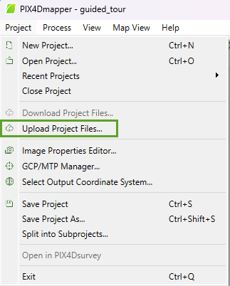
- Processing: Datasets are processed with the new pipeline using a nadir or oblique template.
- Cloud Input: Only the input images, the CRS from the .p4d file and, if present, GCPs/Marks are used.
- Important: All other settings in the .p4d file are ignored.
-
No custom settings are applied.
-
- The "Upload Project Files..." button is still available in PIX4Dmapper, but projects uploaded to PIX4Dcloud are processed as follows: ojects uploaded to PIX4Dcloud will be processed with the following changes:
-
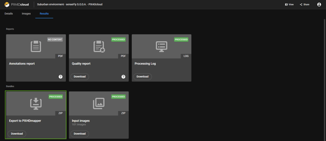
PIX4Dmapper datasets uploads + PIX4Dcloud Starter/PIX4Dcloud Pro processing + Export to PIX4Dmapper from PIX4Dcloud:
- The "Export to PIX4Dmapper" option (zip download) is no longer available in PIX4Dcloud Starter/PIX4Dcloud Pro.
-
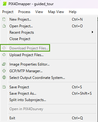
PIX4Dmapper datasets uploads + PIX4Dcloud Starter/PIX4Dcloud Pro processing + Download Project Files.. from PIX4Dmapper:
- The "Download Project Files..." button in PIX4Dmapper is greyed out for projects processed in PIX4Dcloud since February 28, 2026.
Alternatives and recommended workflows
For workflows that relied on the legacy pipeline, use the alternatives below. If you are unsure which PIX4D product fits your workflow, contact PIX4D Support at https://www.pix4d.com/support/. - Alternatives to specific PIX4Dmapper features in other PIX4D products:
- Multispectral imagery: PIX4Dfields.
- Thermal imagery: PIX4Dmatic.
- Fisheye lens camera:
- PIX4Dmatic: fully supported.
-
-
- PIX4Dcloud: partially supported, except for Gaussian splats and virtual inspector.
- Images without geotags (arbitrary): PIX4Dmatic.
- Manually marking MTP/2D GCPs/3D GCPs/Checkpoints: PIX4Dmatic.
- Scale constraints: PIX4Dmatic.
- Orientation constrains: PIX4Dmatic.
- Site calibration or localization: PIX4Dmatic.
-
-
- Export 3D mesh:
- .ply file format: PIX4Dmatic.
- 3D mesh color balance: PIX4Dmatic (the texture file is color balanced, but at the tile level).
- Export Grid DSM: PIX4Dsurvey (grid of points).
- Export orthomosaic (.kml file format): PIX4Dmatic.
- Contour lines: PIX4Dsurvey.
- Digital Terrain Model (DTM): PIX4Dsurvey.
- Index maps: PIX4Dfields.
- Export 3D mesh:
- Other forms of processing:
- Process the datasets directly in PIX4Dcloud Starter/PIX4Dcloud Pro: New dataset > Dataset creation > Upload images - PIX4Dcloud.
- Use the Share to PIX4Dcloud feature: Users can process the dataset using the proposed alternatives, and once the results are generated, upload them to PIX4Dcloud Starter/PIX4Dcloud Pro for visualization. For more information: