Automatic reports can be generated at any time during the inspection process.
ContentPIX4Dinspect can record, compile and list annotations, as soon as they are added to the images, together with the AI recognized antennas.
Reports contain information about:
- The user generating the report.
- The asset properties.
- The project details.
- An overview of the image annotations.
- A full catalog of the single annotations per image with the image annotation details.
- The antennas' inventory.
The available formats for the report generation are:
JSON
Reports exported in this format can be used to produce customized reports or other outputs with third-party applications.
JSON example
"reported_by": {
 "name": "FirstName LastName",
 "email": "user@domain.com",
 "report_units": "metric",
 "country": "CH",
 "preferred_language": "en-US",
 "id": 17
} "asset": {
"name": "CT-0016",
"type": "Cell tower",
"latitude": "43.80577000",
"longitude": "11.29229000",
"description": "Lattice tower, single-operator",
"created_at": "2020-02-19T16:58:45.709788+01:00",
"updated_at": "2020-04-17T16:41:26.377201+02:00"
} "inspection": {
"project_id": 650310,
"created_at": "2020-04-09T15:02:56.236643+02:00",
"updated_at": "2020-04-13T09:19:25.651248+02:00",
"width": 5472,
"height": 3648,
"model": "FC6310",
"name": "Inspection for Asset ID 79",
"image_count": 270,
"tower_height": 41.75
} "image_annotations": {
"total": 10,
"severity_summary": {
"level_1": 0,
"level_2": 2,
"level_3": 2,
"level_4": 3,
"level_5": 3,
"other": 0
}
"image_list": [...
{
"annotations": [
{
"id": 528,
"type": "Equipment cabling",
"body": "[[0.436634515462089,0.21699683417669544],[0.436634515462089,0.29618862758517683],
[0.4872357998754213,0.29618862758517683],[0.4872357998754213,0.21699683417669544]]",
"severity_level": 5,
"description": "Un-labeled connecting cable",
"created_at": "2020-04-17T16:43:31.192825+02:00",
"updated_at": "2020-04-17T16:43:40.718600+02:00"
},
{
"id": 529,
"type": "Antenna defect",
"body": "[[0.2504401927984777,0.23297635529744262],[0.2504401927984777,0.3269401168203551],
[0.31580628777093855,0.3269401168203551],[0.31580628777093855,0.23297635529744262]]",
"severity_level": 3,
"description": “Damaged back surface covering”,
"created_at": "2020-04-17T16:43:49.271492+02:00",
"updated_at": "2020-04-17T16:43:51.114969+02:00"
}
],
"name": "DJI_0452.JPG",
"altitude": 640.037,
"altitude_ref": 0,
"latitude": 40.03320439,
"longitude": -3.71371461,
"yaw": "-9.60"
},
{
"annotations": [
{
"id": 526,
"type": "Damaged light beacon",
"body": "[[0.3558151357205312,0.35030863009251195],[0.3558151357205312,0.4095209270905374],
[0.39703153853288226,0.4095209270905374],[0.39703153853288226,0.35030863009251195]]",
"severity_level": 4,
"description": "Change piece",
"created_at": "2020-04-17T16:42:30.736278+02:00",
"updated_at": "2020-04-17T16:42:56.419163+02:00"
},
{
"id": 527,
"type": "Uncategorised",
"body": "[[0.47656178057924975,0.29719171660898913],[0.47656178057924975,0.35553324453351415],
[0.5021043400685941,0.35553324453351415],[0.5021043400685941,0.29719171660898913]]",
"severity_level": 4,
"description": null,
"created_at": "2020-04-17T16:43:06.105245+02:00",
"updated_at": "2020-04-17T16:43:10.197215+02:00"
}
],
"name": "DJI_0441.JPG",
"altitude": 640.137,
"altitude_ref": 0,
"latitude": 40.03324183,
"longitude": -3.71363361,
"yaw": "-62.60"
},
 "inventory": {
 "antennas": [
 {
 "id": 856,
 "ml_data": {
 "type": "panel",
 "depth": 0.17,
 "plumb": 2.11,
 "width": 0.34,
 "height": 1.92,
 "azimuth": 124.12,
 "downtilt": 3.92,
 "height_above_ground": 36.35
 },
 "working": true,
 "frequencies": [
 600,
 800
 ],
 "hardware_id": "MV473",
 "model_name": "NX-484746-US",
 "created_at": "2020-04-13T09:19:25.612412+02:00",
 "updated_at": "2020-04-17T16:48:54.628909+02:00",
 "image": null
 }
 ...
Reports exported in this format collect the information generated during the inspection phase in an organized file with a default Pix4D style.
When generating the PDF report, the user can choose which information will be displayed in it, such as Email, Annotations, Inventory items, Measurements, Remarks, etc., as well as the option to show invisible content and add or not the project's link.

For custom reports, contact our Sales team.
PDF structure
The .pdf report is structured as follows:
- A front-page containing:
- The Asset name.
- Information about the user generating the report.
- The date and time of the report generation.
- The table of contents.
- An Overview section containing:
- A snapshot of the asset on a base map background, taken from the Dashboard.
- A link to the project (the share link needs to be enabled before generating the PDF report).
- The Asset type.
- The location of the asset (WGS84 coordinates that position the Asset onto the map of the Dashboard).
- The project's name.
- Ground reference altitude (Height of the tower's base).
- The tower height (only if Panel antenna recognition is enabled in the Options before processing).
- The description of the Asset.
- The date and time when the Project was created.
- An Annotations section containing:
- The total number of annotations of the project.
- The number of annotations per severity level.
- The full list of annotations with their type, severity level, and description
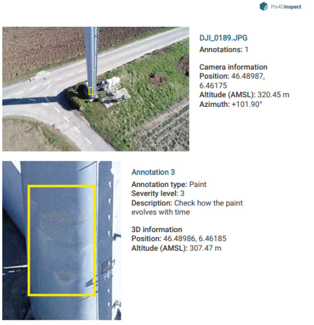
for each annotated image: - The image with its name, its number of annotations, its position, and yaw angle.
- In greater detail, for each annotation of the image, an enhanced cut-out of the annotation area together with the annotation’s properties (type, severity level, and description).
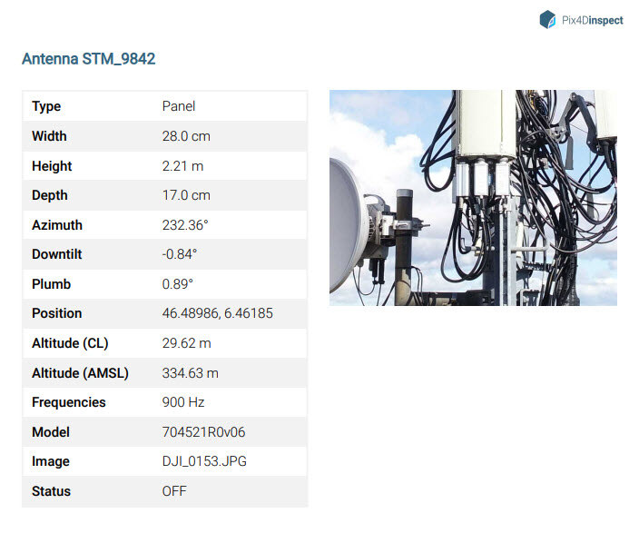
- An Inventory section containing:
- The full list of antennas with their ID and type.
For each antenna: - Its properties: name, type, dimensions and orientations, altitude, supported frequencies, model, status.
- If any, the image chosen as best fit with the zoom level and image framing that were active when defining the image as such.
- The full list of antennas with their ID and type.
- The 2D Plans of the project (only for telecom towers projects):
- A 2D view snapshot of the Top of the tower.
- A 2D North view of the tower, along with its height.
- A 2D East view of the tower, along with its height.
- A 2D South view of the tower, along with its height.
- A 2D West view of the tower, along with its height.
- Top-bottom, where it is represented the area defined by the baseplate and all the existing future installation cabinets that are fully inside the baseplate area.
- Side views, 4, north, east, south, and west, where all the inventory item boxes are represented independently from the Status (Active, Inactive, Future Installation). Point type items are not represented.
- A Measurements section containing:
- The total number of measurements of the project.