How to export spot spraying and variable rate prescriptions for DJI Agras T-series with PIX4Dfields
The following article describes exporting spot spraying and variable rate prescriptions using the PIX4Dfields Targeted Operation feature.
IN THIS ARTICLE
Introduction
Exporting boundary mission
Exporting Variable Rate Application (VRA) format
Import map into DJI Agras controller
Introduction
The DJI Agras T-series supports different file types and prescription maps, depending on the mission type and the specific Agras model.
When exporting Targeted Operations to the DJI Agras T-series, there are two available formats:
- Go to Export, Operations.
- Select the Operation to be exported.
- Select DJI Agras (T-series)
- DJI Boundary Mission: it is useful for exporting a field's boundaries or in specific cases where spot spraying is feasible.
- DJI VRA Format: suitable for most applications, it allows exporting a Variable Rate Application (VRA) map.
Warning: "There are no rates assigned to any cell":
- A rate must be specified when exporting as a Boundary mission.
- Adding a rate is optional when exporting in VRA format.
Exporting DJI boundary mission
Exporting boundaries is useful for determining the area extent of a mission and applying a fixed rate to it.
- All Agras drones are compatible with this export format. DJI AGRAS T10, T20, T30, T40, T50 and T100.
- If this option is unavailable in PIX4Dfields, exporting it as a DJI VRA mission might be the best solution. For more information: Disabled DJI Agras boundary mission - PIX4Dfields
Each boundary exported will result in a single flight mission on the remote controller.
- Exporting field boundaries: please follow How to Export Boundaries for DJI Agras T-Series in PIX4Dfields.
- Spot spraying (limited): When application areas are large and distinct, spot spraying is also possible with this export format.
- In this case, the application map is ready using the Targeted Operation feature.
Flying over the violet zone requires applying 10 liters of growth regulator.
- It will export one folder called "DJI" with a shapefile inside.
Each area inside the prescription map will be differentiated when imported into the RC controller:
- In this case, the application map is ready using the Targeted Operation feature.
When should I use the Boundary mission?
DJI Agras Boundary missions are helpful in cases where one rate is applied, or there are very distinguished areas (more than 3 hectares), and they can be exported as boundaries.
When using the DJI Agras T25 and T50, Boundary mission allows Multitask operations.
Multitask operations for Agras T50 and T25.
These Agras models allow importing a shapefile with multiple polygons, and the drone will fly them consecutively, one after the other.
DJI T50/T25 Firmware Update(July 2024
Agras Tutorial: Spray Multiple Fields with One Flight

Exporting Variable Rate Application (VRA) format
DJI Agras T20, T30, T40, T50 and T100 drones support this format except for the DJI Agras T10.
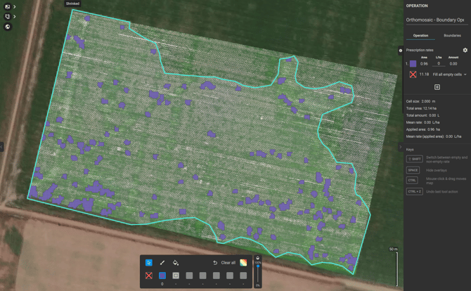
Total boundary area that the drone will fly: 15 hectares.
Total area to be sprayed: 0.96 hectares.
Set the proper rate to be applied. Editing on the remote controller is not possible.

Reducing Total Flying Area
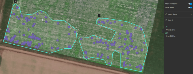
Before exporting the prescription map to the DJI Agras, you can manually create a new boundary to shrink the area and reduce flying over non-application zones.- Click on the Operation layer on the left.
- Click on the Boundary icon.

- Draw the new boundary, reducing the extent.

- Click on the previous Boundary and delete it
 .
. - The total area was reduced by 20%, from 15 to 12 hectares.

- Creating multiple boundaries can also be beneficial, as each boundary will correspond to a separate flight when planning the application on the remote controller:

- VRA map imported into Agras remote controller. Each boundary is converted into a flight plan:
.jpeg?width=475&height=267&name=WhatsApp%20Image%202024-09-03%20at%2013.40.56%20(1).jpeg)
.jpeg?width=479&height=269&name=WhatsApp%20Image%202024-09-03%20at%2013.40.56%20(2).jpeg)
Export the final prescription map:
- Go to Export, Operations.
- Select the Operation to be exported.
- Select DJI Agras (T-series), DJI VRA mission.
- Set the Flight height, which is recommended between 1.5 and 3 meters, and the Spraying width, which should be around 5 meters.
- It will export a "DJI" folder with two sub-folders:
- Shapefile:
It will contain a shapefile with the boundary of the mission. - Rx:
It will contain a .tiff file with different rates following each operation (zone).
- Shapefile:
When should I use the Variable rate missions?
- DJI Agras VRA missions should be used when multiple rates are applied or when complex spot spraying missions are performed.
- The downside is that the boundary should be edited when doing Spot Spraying, to reduce flying over the non-application areas.
Import map into DJI Agras controller
Aircraft:01.00.0602, Remote Controller:01.00.0602, APP:5.5.3.
After exporting the desired format from PIX4Dfields:
- Copy-paste it into the SD card.
- Remove the SD card from the laptop and insert it into the DJI controller. Then, power on the controller.
- Click on the SD Card icon, and choose microSD.
- Select the proper boundary under Task, and click Import:

- For a VRA application, click Prescription Map and select the file.

- The Importing Prescription Map menu will appear:

-
- Select Map Source: Other.
- Select the Source unit: ha, no matter the units being used.
- Set the Resample option:
- Max Value: this will apply the max rate when the drone passes over two cells.
- Average Value: this will apply the average rate when the drone passes over two cells.
Load the prescription to the field
Once the Boundary and Prescription are imported, the VRA must be assigned to the field.
- Access the boundary field and click the + folder to assign the Prescription.

- Select the Prescription from the menu.

- Click Use

What if the rates and total volume are not correctly displayed in the controller?
If the rates or total volume are not correctly displayed after importing the prescription:
-
Confirm that, during import, you selected:
Map Source: Other, Source unit: ha, and Resample: Max value. - Perform a short test flight. In most cases, the controller display is inaccurate, but the drone still applies the correct rates in the field.
Set desired flight parameters, load the product, and fly.
Safe flights!
