Create a new dataset to start processing imagery and create maps and digital twins of the reality or upload outputs to PIX4Dcloud.
Access: To import the GCPs coordinates, navigate to step 5 of the project wizard.
Licenses: This article is only valid for PIX4Dcloud Pro licenses (formerly PIX4Dcloud Advanced).
Roles: Only Owners, Managers, and Editors can create and process datasets in PIX4Dcloud.
| 1.Dataset creation > | 2. Image selection > | 3.Output coordinate system > | 4.Processing options > | 5. GCPs automation |
| Processing with GCPs/checkpoints / | Processing without GCPs/checkpoints |
To process a project with GCPs:
- Select Upload file.
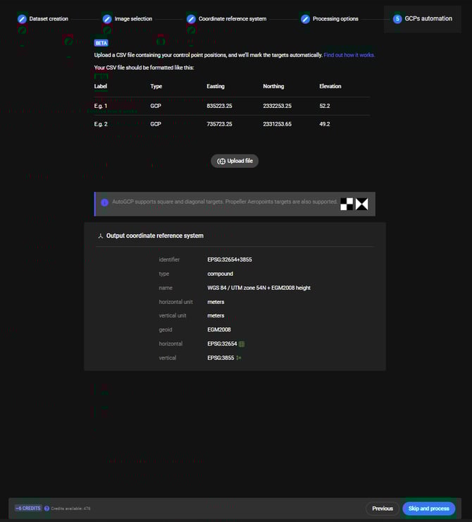
- Browse the CSV file which contains the GCPs' details and click Open.
- The GCPs are imported.
Note that the CSV file has to be in a certain format before being imported. For more information, Upload the GCP file. - The Map displays the geolocation of the GCPs,the checkpoints, the location of the images and the region of interest if it has been defined in Step 2.

- (Optional) Click Replace file to upload a new GCP file.
- (Optional) Click
 to delete the GCP file.
 - (Optional) Click Table. Switch between the two following options:
- Control point table: the control points table lists the imported control points and their properties.
For more information, See and edit the defined control points.
- Control point table: the control points table lists the imported control points and their properties.
- Click Process to finalize the new project creation.
Information:
- Once the dataset begins processing, it is no longer possible to add more images or make changes to the processing options.
- If changes to the processing options are necessary after the dataset has already begun processing, a new project must be created and processed from scratch.
- If a user is unsure whether all images will be uploaded to the project (due to internet connection issues) or believes more will be necessary, PIX4D recommends disabling the "Start Processing Automatically" option. This will allow more images to be manually added before beginning dataset processing.
Warning: The output coordinate reference system defined in step 3 of the project wizard (Coordinate reference system) has to be the one in which the GCPs and checkpoints were measured.
Note:
- Note that there are alternative methods for processing datasets with Ground Control Points (GCPs) or checkpoints on PIX4Dcloud that do not require an Pro license. For more information, see How to use Ground Control Points (GCPs) for processing on PIX4Dcloud.
- For more information about autoGCP algorithms, AutoGCPs detection functionality.