This article explains how to select vertical coordinate reference systems, geoid, or geoid height in PIX4Dsurvey. Selecting the correct vertical coordinate reference system is important to geolocate the reconstruction and the elements within accurately.
For more information, see the Orthographic (geoid) vs. ellipsoidal heights article.
PIX4Dmatic and PIX4Dsurvey support global geoids (EGM84, EGM96, and EGM2008) and local geoids, for example, GEOID12B in the US and OSGM15 in the UK.
For local geoids that are not included in the PIX4Dmatic and PIX4Dsurvey database, it is possible to specify the Geoid height value to convert between ellipsoidal and orthometric heights.
IN THIS ARTICLE
Selecting the vertical coordinate reference system
Selecting the geoid
Selecting the geoid height
List of supported geoids
Importing geoids
Access
Useful information
Selecting the vertical coordinate reference system
After selecting the Horizontal coordinate reference system, the list of Vertical coordinate reference systems is available.
Only Vertical coordinate reference systems within the area of use of the Horizontal coordinate reference system are listed.
Selecting the geoid
Several geoid models are available in the PIX4Dmatic and PIX4Dsurvey databases. The full list is available in the List of supported geoids section.
The list of available geoids depends on the selected vertical coordinate reference frame.
Selecting the geoid height
When the geoid corresponding to the selected vertical reference frame is not available, it is possible to specify the Geoid height value, which represents the height between the base ellipsoid of the horizontal coordinate reference system and the desired geoid.
The Geoid height value is used to convert the image geolocation (WGS 84 ellipsoid or EGM96 geoid) into the desired project coordinate system.
List of supported geoids
| Country or region | Vertical coordinate reference system | Geoid | Note |
|---|---|---|---|
| Global | EGM96 height - EPSG:5773 | EGM96 | 15' geoid |
| EGM2008 height - EPSG:3855 MSL height - EPSG:5714 |
EGM2008 | 2.5' geoid | |
| Argentina | SRVN16 height - EPSG:9255 | GEOIDE-Ar16 | |
| Australia | AHD height - EPSG:5711 AHD (Tasmania) height - EPSG:5712 |
AUSGeoid98 | |
| AHD height - EPSG:5711 AHD (Tasmania) height - EPSG:5712 |
AUSGeoid09 | ||
| AHD height - EPSG:5711 | AUSGeoid2020 | ||
| Austria | EVRF2000 Austria height - EPSG:9274 | Austrian Geoid 2008 | |
| GHA height - EPSG:5778 | Austrian Geoid 2008 | GHA | ||
| Belgium | Ostend height - EPSG:5710 | hBG18 | |
|
Canada |
CGVD28 height - EPSG:5713 | CGG2000/HTv2.0 | |
| CGVD2013(CGG2013) height - EPSG:6647 | CGG2013 | ||
| CGVD2013(CGG2013a) height - EPSG:9245 | CGG2013a | ||
| Corsica | NGF-IGN78 height - EPSG:5721 | RAC09 | |
| NGF-IGN78 height - EPSG:5721 | RAC23 | ||
| Czech Republic | Baltic 1957 height - EPSG:8357 | CR-2005 | |
| Denmark | DVR90 height - EPSG:5799 | DVR90 | |
| DNN height - EPSG:5733 | DNN | ||
| Faroe Islands | FVR09 height - EPSG:5317 | FVR09 | |
| Finland | N60 height - EPSG:5717 | FIN2000 | |
| N2000 height - EPSG:3900 | FIN2005N00 | ||
|
France |
NGF-IGN69 height - EPSG:5720 | RAF09 | |
| NGF-IGN69 height - EPSG:5720 | RAF18 | ||
| NGF-IGN69 height - EPSG:5720 | RAF18b | ||
| NGF-IGN69 height - EPSG:5720 | RAF20 | ||
| Germany | DHHN2016 height - EPSG:7837 | GCG2016 | |
| Greenland | GVR2000 height - EPSG:8266 | GGEOID2000 | |
| GVR2016 height - EPSG:8267 | GGEOID2016 | ||
| Iceland | ISH2004 height - EPSG:8089 | IceGeoid2011 | |
| Japan | JGD2011 (vertical) height - EPSG:6695 | GSIGEO2011 | |
| Latvia | Latvia 2000 height - EPSG:7700 | LV14 | |
| Mexico | NAVD88 height - EPSG:5703 | GGM10 | |
| Netherlands | NAP height - EPSG:5709 | NLGEO2018 | |
| Bonaire height - EPSG:10763 | BONGEO2004 | ||
| New Zealand | NZVD2009 height - EPSG:4440 | NZGeoid2009 |
Meant to be used with an NZ horizontal CRS |
| NZVD2016 height - EPSG:7839 | NZGeoid2016 | ||
| Auckland 1946 height - EPSG:5759 | NZGeoid2016 | Auckland 1946 | ||
| Bluff 1955 height - EPSG:5760 | NZGeoid2016 | Bluff 1955 | ||
| Dunedin-Bluff 1960 height - EPSG:4458 | NZGeoid2016 | Dunedin-Bluff 1960 | ||
|
Dunedin 1958 height - EPSG:5761 |
NZGeoid2016 | Dunedin 1958 |
||
|
Gisborne 1926 height - EPSG:5762 |
NZGeoid2016 | Gisborne 1926 |
||
|
Lyttelton 1937 height - EPSG:5763 |
NZGeoid2016 | Lyttelton 1937 |
||
|
Moturiki 1953 height - EPSG:5764 |
NZGeoid2016 | Moturiki 1953 |
||
|
Napier 1962 height - EPSG:5765 |
NZGeoid2016 | Napier 1962 |
||
|
Nelson 1955 height - EPSG:5766 |
NZGeoid2016 | Nelson 1955 |
||
|
One Tree Point 1964 height - EPSG:5767 |
NZGeoid2016 | One Tree Point 1964 |
||
|
Stewart Island 1977 height - EPSG:5772 |
NZGeoid2016 | Stewart Island 1977 |
||
|
Taranaki 1970 height - EPSG:5769 |
NZGeoid2016 | Taranaki 1970 |
||
|
Wellington 1953 height - EPSG:5770 |
NZGeoid2016 | Wellington 1953 |
||
| Norway | NN2000 height - EPSG:5941 | HREF2018b | |
| Norway / Svalbard | SVD2006 height - EPSG:20000 | arcgp-2006-sk | |
| SVD2024 height - EPSG:10999 | Svalbard_EGG2015_2024 | ||
| Poland | Baltic 1986 - EPSG:9650 EVRF2007-PL height - EPSG:9651 |
PL-geoid-2011 | |
| EVRF2007-PL height - EPSG:9651 | PL-geoid-2021 | ||
| Portugal | Cascais height - EPSG:5780 | GeodPT08 | |
| Singapore | SHD height - EPSG:6919 | SGeoid09 | |
| Slovakia | Baltic 1957 height - EPSG:8357 | DVRM05 | Only available to Baltic 1957 height |
| Slovenia | SVS2010 height - EPSG:8690 | SLO_VRP2016/Koper | |
| South Africa | SA LLD height - EPSG:9279 | SAGEOID2010 | |
| Spain | Alicante height - EPSG:5782 | EGM08-REDNAP | |
| Sweden | RH2000 height - EPSG:5613 | SWEN17 | |
| Switzerland | LN02 height - EPSG:5728 LHN95 height - EPSG:5729 |
CHGeo2004 | |
| Taiwan | TWVD 2001 height - EPSG:8904 | TWGEOID2018h | |
| UK | Belfast height - EPSG:5732 Douglas height - EPSG:5750 Lerwick height - EPSG:5742 Malin Head height - EPSG:5731 ODN (Offshore) height - EPSG:7707 ODN height - EPSG:5701 ODN Orkney height - EPSG:5740 St. Marys height - EPSG:5749 Stornoway height - EPSG:5746 |
OSGM15 | Including Great Britain, Ireland, and North Ireland |
| US | NAVD88 height - EPSG:5703 NAVD88 height (ft) - EPSG:8228 NAVD88 height (ftUS) - EPSG:6360 |
GEOID99 | |
| NAVD88 height - EPSG:5703 NAVD88 height (ft) - EPSG:8228 NAVD88 height (ftUS) - EPSG:6360 |
GEOID03 | ||
| NAVD88 height - EPSG:5703 NAVD88 height (ft) - EPSG:8228 NAVD88 height (ftUS) - EPSG:6360 |
GEOID06 | ||
| NAVD88 height - EPSG:5703 NAVD88 height (ft) - EPSG:8228 NAVD88 height (ftUS) - EPSG:6360 |
GEOID09 | ||
| NAVD88 height - EPSG:5703 NAVD88 height (ft) - EPSG:8228 NAVD88 height (ftUS) - EPSG:6360 |
GGM10 | ||
| NAVD88 height - EPSG:5703 NAVD88 height (ft) - EPSG:8228 NAVD88 height (ftUS) - EPSG:6360 NMVD03 height - EPSG:6640 PRVD02 height - EPSG:6641 VIVD09 height - EPSG:6642 ASVD02 height - EPSG:6643 GUVD04 height - EPSG:6644 |
GEOID12A | ||
| NAVD88 height - EPSG:5703 NAVD88 height (ft) - EPSG:8228 NAVD88 height (ftUS) - EPSG:6360 NMVD03 height - EPSG:6640 PRVD02 height - EPSG:6641 VIVD09 height - EPSG:6642 ASVD02 height - EPSG:6643 GUVD04 height - EPSG:6644 |
GEOID12B | ||
| NAVD88 height - EPSG:5703 NAVD88 height (ft) - EPSG:8228 NAVD88 height (ftUS) - EPSG:6360 PRVD02 height - EPSG:6641 VIVD09 height - EPSG:6642 |
GEOID18 |
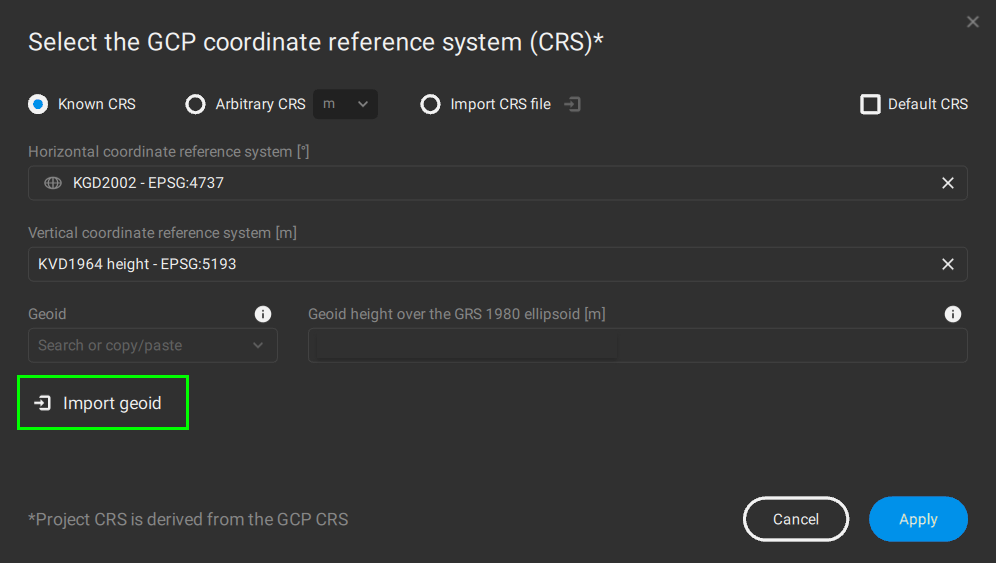
Importing geoids
Access
Ensure the following requirements concerning coordinate reference systems are fulfilled.
- Download the respective file.
- This file can be downloaded only via the official authorities.
- Set the vertical coordinate reference system according to the table below.
Then, a new option, ![]() Import geoid will be visible.
Import geoid will be visible.
List of supported geoid models for import
| Country or region | Vertical coordinate reference system | Geoid | Source | File name |
|---|---|---|---|---|
| Estonia | EH2000 height- EPSG:9663 | EST-GEOID2017 | Avaleht | Geoportaal | Maa-amet | EST-GEOID2017.BLN |
| Lithuania | LAS07 height - EPSG:9666 | LIT20G | Nacionalinė žemės tarnyba prie Aplinkos ministerijos |
LIT20G.txt |
| South Korea | KVD1964 height - EPSG 5193 | KNGeoid18 | National Geographic Information Institute of South Korea (NGII) | KNGeoid18.dat |
| KNGeoid24 | National Geographic Information Institute of South Korea (NGII) | hybrid_geoid.dat |
Useful information
- After successfully importing it, this geoid will be used as any other geoid model.
- Importing a custom geoid file needs to be done only once.
- Any new project created afterward will have the custom geoid model already available. This also applies after installing a later version of PIX4Dmatic/PIX4Dsurvey.
- When importing the custom geoid file into PIX4Dmatic version 1.57 or newer, it will also be available in the equivalent version of PIX4Dsurvey and vice versa.