Licenses: This article is valid for PIX4Dcloud Starter and PIX4Dcloud Pro licenses (formerly PIX4Dcloud Advanced).
Roles: Only Owners, Managers, and Editors can replace outputs in a datasets in PIX4Dcloud.
Overview
Information:
-
For datasets already processed in PIX4Dcloud, uploading new outputs replaces the existing results but does not delete the dataset.
-
Pix4D recommends uploading outputs in a projected coordinate system for accurate visualization and measurements.
Important processing warning
Warning:
-
If a project has been partially processed in PIX4Dmapper and then uploaded to PIX4Dcloud for processing, the processing steps will be repeated in the cloud.
- Significant changes to the PIX4Dmapper upload workflow to PIX4Dcloud have been implemented since February 2026. For more information Decommissioning Notice: PIX4Dmapper Legacy Processing Pipeline in Cloud Products.
Example:
-
Step 1 and Step 2 are processed in PIX4Dmapper.
-
The point cloud is edited locally.
-
The project is uploaded to PIX4Dcloud for processing.
-
Step 1 and Step 2 are reprocessed in PIX4Dcloud, and local point cloud edits are lost.
Supported output files
The full list of supported outputs and required formats is available here: Inputs.
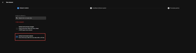
Uploading outputs to a new dataset
(No images processed in PIX4Dcloud)
To upload outputs to a new dataset:
- Go to PIX4Dcloud and log in with a valid Pix4D account.
- Create a new dataset and select Upload processed results.
- In Files & Reports > Results, click Upload File for the corresponding output, or drag and drop the file(s) into the appropriate section.
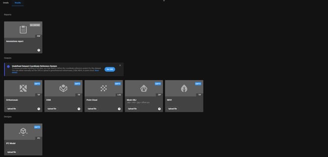
- Monitor the upload progress in the upload window. Once completed, click CLOSE.
- If uploading a 3D textured mesh, review the recommendations in the section below.
- About geographic coordinate systems: If outputs are provided in a geographic coordinate system (for example, WGS84), the following limitations apply:
-
Cartesian coordinates (X, Y) are not accurate because geographic systems use angular units.
-
Distance, area, and volume measurements are inaccurate, as they rely on Cartesian coordinates.
-
Uploading or replacing outputs in an existing dataset
For datasets that were already processed in PIX4Dcloud or already contain uploaded results:
-
Go to PIX4Dcloud and log in.
-
Open the existing dataset.
-
In Files & Reports > Results, click Replace File for the output to be updated, or drag and drop the file(s) into the corresponding section.
-
Wait for the upload to complete and click CLOSE.
3D OBJ Mesh upload recommendations
OBJ 3D textured meshes are not georeferenced by default. When generated with Pix4D products, an offset.xyz file is created alongside the mesh. Uploading this file is recommended in the following cases:
-
Both the point cloud and the 3D textured mesh are uploaded, to ensure proper alignment.
-
A georeferenced 3D textured mesh is required.
-
Annotations are created and visualized in both 2D and 3D.
Information: All required files must be uploaded at the same time.
Recommended workflow
-
Copy the offset.xyz file into the
3d_meshfolder. -
Drag and drop the
.obj,.mtl,.jpg, and.xyzfiles into the Mesh OBJ section under Files & Reports > Results. -
Wait for the upload to complete.
Once finished, the georeferenced 3D mesh is available in PIX4Dcloud.
Important texture limitation:
The OBJ mesh texture to import must be a single JPG image. PIX4Dcloud does not support the import of OBJ meshes with multiple JPG texture files.
To upload an OBJ mesh with multiple textures, do one of the following:
-
Generate a new OBJ mesh with a single JPG texture.
-
Merge the existing texture images into a single JPG file.