How to generate an Elevation profile on PIX4Dcloud

Follow

Requirements

The Elevation profile is only available under one of these conditions (alternative):

  • The project has been processed on PIX4Dcloud, it is georeferenced and contains a DSM.
  • A DSM was uploaded as a result to PIX4Dcloud and is georeferenced.

To visualize the profile in the 3D view, the Point Cloud or 3D Textured Mesh should be generated or uploaded beside one of the conditions above. 

Generate an Elevation Profile

  1. Open an existing project.
  2. Select the 2D or 3D view. The 3D view is recommended in order to ensure the correct starting and ending points are picked.
  3. Add a distance measurement: click ic_line_black.png or add an item to the Annotations layer by clicking add.png when hovering it and select Measure a distance or elevation.
  4. Draw a (poly)line. Double-click to end it.
  5. On the right, on the details panel, click Generate elevation profile.

If the Elevation profile does not load, check this troubleshooting article: Output is not displayed / feature is missing on PIX4Dcloud.

Measure on an Elevation profile
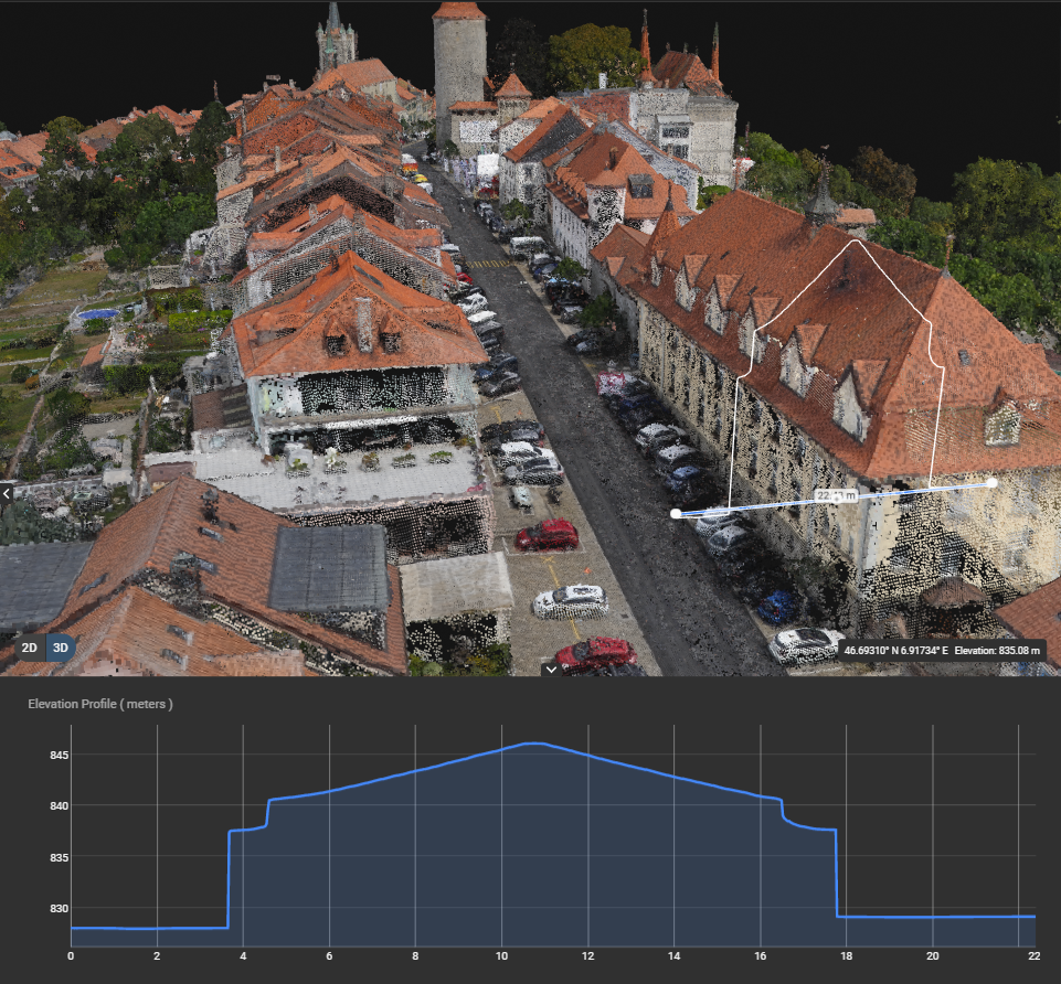
elevation_profile.png

On the bottom panel, move the mouse along the curve to display the elevation and its location on the profile. Zoom in for more precision. The zoom level on the curve can be reset by clicking Reset Zoom in the Elevation profile panel.

The horizontal axis represents the length of the (poly)line whose origin (0 value) corresponds to the first clicked point.

The vertical axis corresponds to the elevation of the map/model. More information about the coordinate system in Georeferencing of datasets, outputs and annotations on PIX4Dcloud.

The elevation is computed on the DSM for each pixel of the (poly)line. By default, the resolution is the ground sampling distance (GSD) of the project.

Export an Elevation profile

In the Elevation profile panel, click export.png to export the Elevation profile as a CSV file and save to desktop all its 3D points.

The following columns are exported:

  • X, Y: horizontal coordinates in the output coordinate system or the one detected in the uploaded DSM.
  • Z: vertical coordinate in the vertical output coordinate system or the one detected in the DSM, in meters or feet depending on the account preferences.
  • Distance: ground distance from the origin of the profile in meters or feet depending on the account preferences.
Was this article helpful?
15 out of 18 found this helpful

Article feedback (for troubleshooting, post here instead)

12 comments

  • Ara-spd-totts Donohoe

    The elevation profile tools looks just great! Unfortunately, I work in an environment where uploading this sort of data to "The Cloud" would be a violation of security. As a result, I am forced to squeeze these sorts of measurements out of the desktop software by other means that are not nearly as elegant or even representative of the actual capabilities of Pix 4D. My clients are left wondering if they should be looking at a different software package for using photogrammetry as a tool for measurement. I am wondering if the BIM version has additional capabilities that might make up for the measurement tools that are missing from the desktop version. It would be very nice to see these capabilities in the desktop version. 

  • Holden (Pix4D)

    Hello. Thank you for your feedback regarding the elevation profile tool. Incorporating this feature into Pix4D mapper could be considered in the future. All features available in the desktop Pix4D BIM are available in Pix4D Mapper. Currently, you could generate an elevation profile locally using the DSM/DTM produced in Pix4D and importing into a GIS program like ArcMap. I will pass on your comments to our mapper development team. 

  • matt lyreco

    Hi,

    is there an explanation why the results have to be georeferenced to show the elevation profile? 

    for example if i use gcps that are in site coordinate system for different reasons (when appended and merged with all other design it will fall directly on the right spot.)

    for now all other features are available when having an arbitrary model. (volume, dsm color map intervals, marker, area) therefore i wonder why elevation profile is not included?

  • Holden (Pix4D)

    Hi Matt. This has been something that other users have mentioned and our cloud team is considering. I will pass on your comments to help let them know this is a feature that is still of interest. Thanks for the feedback!

  • Arthur Gremaud

    Hi do you have any news about the desktop feature ? Thanks

  • Avatar
    Beata (Pix4D)

    Hi Arthur,

    Unfortunately, until now we have not received any news when about Elevation Profile Tool for Desktop. However, this suggestion is one of the most popular for our future releases. I am confident that our developers and Products Owners will do what they can to meet the customer's demands.

    Best 

  • Avatar
    Beata (Pix4D)

    Hi Artur,

    Could you also explain to us why you would prefer using this tool on the desktop instead of the cloud?

    Thanks in advance.

  • Mark Steggall

    Hello
    Can you show vertical distance achieved above a design or sub base design height?

    This would be useful in a project I'm working on where we need to verify we have placed 100 mm of rock on a new road construction

    Regards
    Mark

  • Alice (Pix4D)

    Hello Mark,

    The elevation profile is generated on the DSM. If you need to evaluate the new part that was added, you need to replace the DSM with the new one containing the added part and then compare the two elevation profiles in another software, if every time you export the profile in the CSV format.

  • Adriano Morel

    Hello.

    I would like to do that on a crop ortho/dsm done by drones. My question is, what's the perfect flight altitude to give me an accurate information?

  • Christovel Natar Pardo

    Hello,

    I want to ask about cross section. I want to lay out cross section on other software like ArcMap. What file should I input to ArcMap after I build cross section?
    Thanks 
    Best Regards

  • Avatar
    Marco (Pix4D)

    Hi @Adriano,
    It will depend on your terrain and on the resolution you want. I recommend you to read how articles on this topic:
    Accuracy-of-Pix4D-outputs
    Ground-sampling-distance-GSD

    Hi @Christovel,

    There is no such tool in Pix4Dmapper as it is made for processing and generating the outputs.
    You should use the DSM or DTM.
    Pix4D-outputs-with-other-software-by-output

    Best

Article is closed for comments.