PIX4Dmapper can process projects with or without ground control points (GCPs). Accurate GCPs increase the global accuracy of the project. GCPs can be:
- Measured in the field with topographic methods. For more information: Step 1. Before Starting a Project > 4. Getting GCPs on the field or through other sources (optional but recommended).
- Extracted from existing geospatial data.
- Extracted from a web map service (WMS). For more information: How to obtain the georeference using 2D or 3D GCPs taken from a Web Map Service .
There are alternative methods to add (import the point coordinates) and mark (click the point on the project images) GCPs depending on:
- The geolocation of the images.
- The coordinate system of the images.
- The coordinate system of the GCPs.
The table below presents the different cases that can occur and which method can be used to add and mark GCPs so that they are considered during the computation and final result.
For more information about the:
- The coordinate system of the GCPs: Menu Project > GCP / MTP Manager... > GCP Coordinate System.
- The coordinate system of the images: Menu Project > Image Properties Editor... > Image Geolocation.
Method A (default)
Description
Method A is used when the image and the GCPs have a known coordinate system that can be selected from Pix4D's database or defined from a .prj file. The two systems do not need to be the same, as Pix4D is able to do the conversion from one to the other.
This is the MOST COMMON CASE. It allows the user to mark the GCPs on the images with little manual intervention. However, this method is not suited for "overnight" processing during which the different processing steps start automatically in a row and do not require any supervision by the user.
Instructions
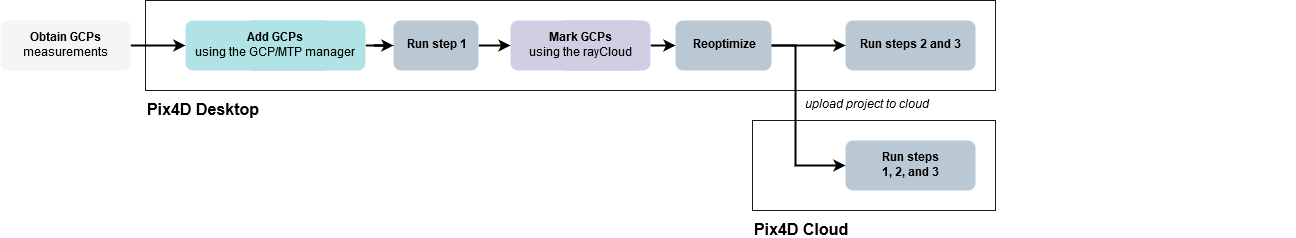
1. Obtain GCPs measurements in the field or through other sources: Step 1. Before Starting a Project > 4. Getting GCPs on the field or through other sources (optional but recommended).
2. Add / Import the GCPs with the GCP/MTP Manager WITHOUT marking them: How to import and mark ground control points (GCPs).
3. On the Menu bar, click View > Processing. The Processing bar appears at the bottom of the Main Window.
4. Select 1. Initial Processing and deselect 2. Point Cloud and Mesh and 3. DSM, Orthomosaic and Index.
5. Click Start.

6. Once Initial Processing is completed, mark the GCPs with the rayCloud: How to mark GCPs in the rayCloud.
7. Click Process > Reoptimize.
8. (optional) Regenerate the Quality Report by clicking Process > Generate Quality Report.
Method B
Description
Method B can be used for the following cases:
- The images are not geolocated: When no GPS was used and no coordinates were given to the images. The GCPs can be in any coordinate system.
- The images are geolocated in an arbitrary coordinate system: This is common when dealing with terrestrial imagery or when reconstructing small objects. The GCPs can be in any coordinate system.
- The GCPs are in an arbitrary coordinate system: The coordinate system of the image geolocation is not relevant.
It allows the user to mark the GCPs on the images with little manual intervention when the images are not geolocated or when the images or GCPs are geolocated in an arbitrary coordinate system. However, this method is not suited for "overnight" processing during which the different processing steps start automatically in a row.

Instructions
1. Obtain GCPs measurements in the field or through other sources: Step 1. Before Starting a Project > 4. Getting GCPs on the field or through other sources (optional but recommended).
2. On the menu bar, click View > Processing. The Processing bar appears at the bottom of the main Window.
3. Select 1. Initial Processing and deselect 2. Point Cloud and Mesh and 3. DSM, Orthomosaic and Index.
4. Click Start.

5. Add / import and mark ONLY 3 of the GCPs in the rayCloud: How to import and mark ground control points (GCPs).
6. After having imported the 3 GCPs and having reoptimized the reconstruction, add / import the remaining GCPs with the GCP/MTP Manager WITHOUT marking them: How to import and mark ground control points (GCPs).
7. Mark the GCPs in the rayCloud: How to import and mark ground control points (GCPs).
8. Click Process > Reoptimize.
9. (optional) Regenerate the quality report by clicking Process > Generate Quality Report.
Method C
Description
Method C works for any case, no matter the coordinate system of the images or GCPs, but it requires more time to mark the GCPs on the images. The advantage of this method is that after importing the images and the GCPs, the processing can be done without any intervention by the user.
It is the best choice for "overnight processing" (i.e leaving the computer processing without any supervision). However, it requires more manual intervention to mark the GCPs on the images. This method is also RECOMMENDED TO PROCESS ON PIX4Dcloud. For more information: How to use GCPs for processing on the cloud platform.
Instructions
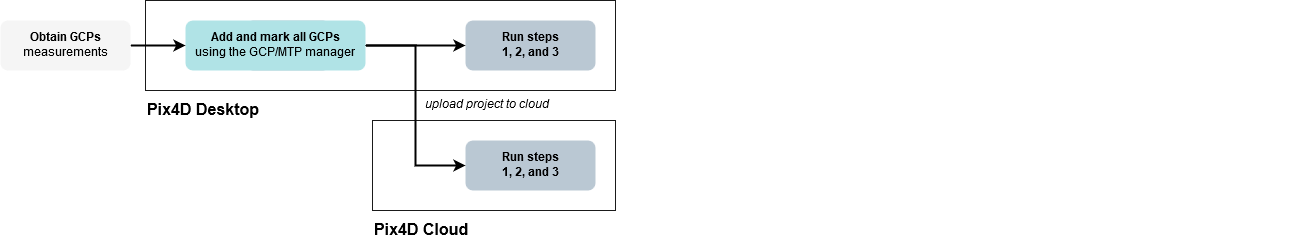
1. Obtain GCPs measurements in the field or through other sources: Step 1. Before Starting a Project > 4. Getting GCPs on the field or through other sources (optional but recommended).
2. Add / import all the GCPs with the GCP/MTP Manager: How to import and mark ground control points (GCPs).
3. Mark the GCPs on the images with the Basic GCP/MTP Editor: How to import and mark ground control points (GCPs).
4. Process all three steps of processing: Step 4. Processing.