This process computes a point cloud classification using the densified point cloud that is generated during step 2.Point Cloud and Mesh. Each point is automatically classified in one of the following predefined groups:
- Ground
- Road Surface
- High Vegetation
- Building
- Human Made Object
The point cloud classification can be performed:
During processing step 2. Point Cloud and Mesh
After processing step 2. Point Cloud and Mesh
In order to perform the point cloud classification while processing step 2. Point Cloud and Mesh:
- On the menu bar, click Process > Processing Options...
- Select the processing step 2. Point Cloud and Mesh.
- Select the tab Point Cloud.
- In the section Point Cloud Classification, select the box Classify Point Cloud.
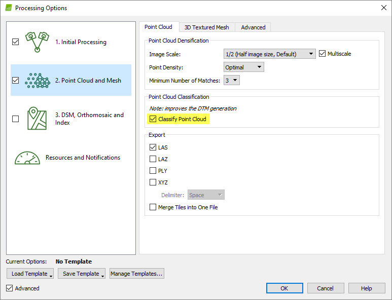
- Click OK.
- Process step 2. Point Cloud and Mesh.
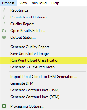
In order to perform the point cloud classification after processing step 2. Point Cloud and Mesh:
- On the menu bar, click Process > Run Point Cloud Classification.
The generated point groups can be visualized in the rayCloud and exported in several file formats:
Visualize the point cloud groups
Export the point cloud groups
Visualize the point cloud groups
The Point Groups layer has a Display Properties sub-layer that can be used to select the point groups to be displayed in the rayCloud. To visualize the point groups using the predefined classification colors the Show Class Color option should be enabled from the drop-down list. When the Show Class Color option is not enabled, the selected point groups are displayed with their original colors.
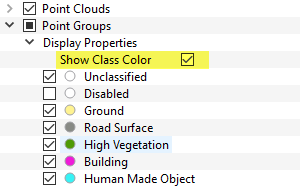
To export the point groups:
1. On the Menu bar, click View > rayCloud.
2. On the left sidebar, in the Layers section expand the Point Clouds list and right click on the densified point cloud's name to be exported.
3. Click Export Point Cloud...
4. In the Export Point Cloud pop-up that appears, select the point group to be exported.
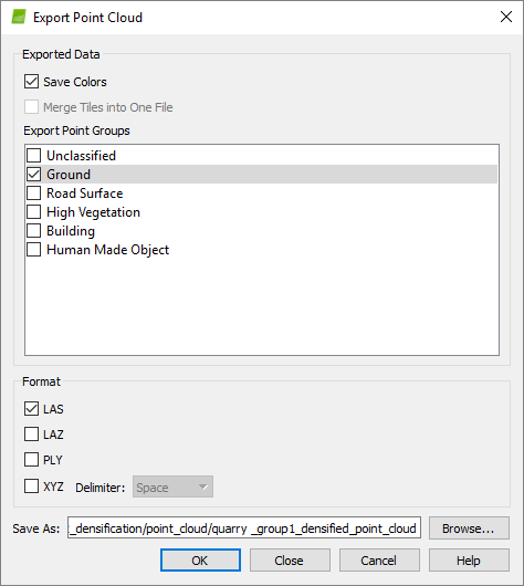
8. Click OK.
The point cloud classification is based on machine learning techniques which require training on labelled data. Both the geometry and the color information are used to assign the points of the densified point cloud in one of the predefined groups. The process performs well for environments similar to the ones of the datasets used for training the algorithm, such as rural, construction and vegetation areas. High vegetation and buildings are well-detected and classified. To learn more about the classification algorithm: Advanced knowledge - Scientific papers.
Depending on the quality of the dataset and the type of terrain, there are areas where the classification is not expected to perform perfectly and there is a need for manual intervention. Mountains, quarries and concrete buildings might need further editing. In the future, more training data will be used to improve the algorithm and give more reliable classification results for different types of projects.
It is possible to edit the point groups to improve the results of the classification. Points can be reallocated among point groups. The points that are erroneously assigned to a point group can be moved to the correct point group using the Edit Densified Point Cloud option: How to edit the point cloud in the rayCloud.
In my cloud point classification,I can get classification.
i find error in ipx4d note,how to solve it?
Error loading boosting model file C:/Users/李阳/AppData/Local/Temp/pix4d.P1XkOA/model.lightgbm
[Error]: Could not load LightGBM model from file: C:/Users/李阳/AppData/Local/Temp/pix4d.P1XkOA/model.lightgbm
[Error]: Error classifying pointcloud: Error classifying point cloud
[Error]: Failed to run classification
By the way,in other time,after run classification,my all points in pointGroups 'Unclassified',What should i do if I want get right point cloud.
Hi Yang,
This issue is related to the project path.
It seems that the 李阳 name in the path creates the problem. Could you please try to create another project using a different path that does not contain folders having special characters or spaces, such as 李阳?
I expect the classification to work this way. If not, please let me know to further investigate the issue.
Best,
Hi Blaž,
Thanks,I have solved this problem.However, the results of point cloud classification are not ideal.If I use point cloud editing in the Raycloud, the workload will be huge. Can I export the original point cloud file of pix4d and try to use other software to classify it?
Li yang
It is possible to export the point cloud and classify it in a third party software. Then you can import external point clouds back into Pix4D and use them for the generation of your DSM, orthomosaic, and all other outputs that are generated in step 3. Read here to learn more about importing an external point cloud into Pix4D for processing.
Hi, what is the purpose of classifying the point cloud? My end goal is to generate contour lines that accurately represent my job site. When I classify the point cloud I notice that it tries to distinguish between man made and natural features among other things. Sometimes it is correct and other times it gets things wrong, but does it affect the contours? Is it worth fixing? What is the purpose of this? Thanks
Keep in mind that the contour lines can be generated based on the DTM or DSM and in case that you want the contour lines to represent the "ground level", we recommend using the point cloud classification.
The results of the point cloud classification are used for the DTM generation during step 3.DSM, Orthomosaic and Index.
This means that the purpose of point cloud classification is to automatically assign points to predetermined groups. Out of these groups (Ground, Road Surface, High Vegetation, Building, Human Made Object), only the Ground and Road Surface groups are preserved in the DTM. To improve the DTM, all the terrain points should be assigned to one of these point groups. To manually move points between the automatically generated point groups, the Edit Densified Point Cloud option can be used: How to edit the point cloud in the rayCloud.
Thank you for the helpful videos and instructions. I have some questions regarding the processing the point cloud classification:
The help article discusses the machine-learning to better classify the point clouds.
Thanks.
Hi Arron, I am glad you were able to find information in the videos and instructions.
As for the question:
Good Afternoon,
Is it possible to create a Grid DSM of only the "Ground" and "Road" point classifications?
Hi Corey,
When generating Grid DSM all points are taken into account regardless of which point class they belong to.
We find your need very relevant and will investigate further what could be done to cover the workflow you mention. We are considering adding this feature to our new product Pix4Dsurvey.
Best,
Thanks for the response. Hopefully this will be available as an update to Pix4Dmapper as we probably do not need all the added functions (and cost) of Pix4Dsurvey.
I look forward to hearing from you with any developments.
Hello there!
I think Pix4D is an excellent software! Very robust and with an intuitive interface.
Regarding the classification of point cloud I think that Pix4D should have options to be inserted by the user to better assist in this step. Today we have to accept what he classifies by itself and we carry out a good part of manual classification. I believe that today one of the biggest problems and processing delay are the cases of MDT and contour lines generation, where this point cloud classification is necessary.
Many processes involving the classification of point cloud I see that Agisoft Metashape has 3 configurations (max. Angle, max distance and cell size) that allow the user to perform the procedure more effectively.
In this example below, Agisofit Metashape helped me to classify about 90% of the area in an automated way with the parameters entered correctly. The rest was done analytically and manually. Note that Pix4D practically did not rank practically anything in this region as ground or road, among many others.

Regards!
Hi Paulo Neto,
Thank you very much for your feedback, we'll consider it!
If you have any other feature suggestion which you'd like to see in on one of our software, please post it on our Community.
Each product has there the Feature Request section where you can register your idea or upvote other suggestions.
Here is how it works.

Regards!
Hello there,
I have some question regarding point cloud classification
1) on the process bar,there is no 'run point cloud classification',only have 'run terrain/object point cloud classification(beta), is it both of this process is same?
2)after 'run terrain/object point cloud classification (beta)is process, there is no point group such as (high vegetation, road surface,etc) and no 'show class color ' options, only have (unclassified,deleted, terrain and object) classes under point group layer. How can i get the different classified point group in automated ways?
I use pix4d for educational purpose only.
Hi Geomatic Rabiah,
Are you using Pix4Dmapper version 4.5.6 or the latest preview? We can only support you with the latest package.
Thank you
I have downloaded pix4D latest version, everything work perfectly, thank you sir for your reminder :)
Hello pix4d,
I have some question regarding the orientation of the image. This problem occur after initial processing step.
After marking all GCP on image using raycloud,i have reoptimize the project, but why initial location of initial position and orientation of images(blue colour) is under the optimized position and orientation(green colour)? As i know the optimized position and orientation should be under the initial position and orientation of images.
Hi Geomatic Rabiah,
I'd highly encourage you to post this question on our Community. There you'll be able to attach the Quality Report and have us looking into the issue. :-)
Thank you and best regards!
Hi pix4d,
How can I obtain the x y z coordinates of points cloud to an excel files after I have created the DTM?
Thank you!
You could export the XYZ format following the instructions: How to export the Point Cloud
I hope it helps!
merhaba pix4d sık ağaçlık olan bir arazide nasıl bir yol deneyebilirim.teşekkürler
birde video sunumu hazırlarken yazı ekleyemiyorum yardımcı olursanız sevinirim.
Hello Bilal,
Would you please post on community and elaborate on it? It will be helpful to assist you.