
IN THIS ARTICLE
Annotation actions in the Details panel
Annotation layer details
Group layer details
Line details
Polygon details
Circle details
Volume details
Marker details
Virtual inspector
Related articles
Licenses: This article is valid for all PIX4Dcloud licenses.
Roles: Only Owners, Managers, and Editors can make permanent changes in the annotations settings in PIX4Dcloud.
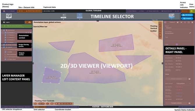
Annotation actions in the Details panel
When an annotation is selected, the Details panel opens on the right side of the viewer. Depending on the annotation type and the user's permissions, the following actions are available:
- Add or replace an image: Add an image to an annotation or replace an existing image. For more information, see How to attach an image to an annotation.
- Update the PDF report: Update the annotation information included in the PDF report.Note: Annotation reports are available only with PIX4Dcloud Pro and higher licenses. For more information, see Annotation report - PIX4Dcloud Pro.
- Focus on annotation: Center the viewer on the selected annotation.
- Delete annotation: Delete the selected annotation.

Annotation Layer details
When clicking the Annotations layer, the details panel opens on the right.
- Name
- (optional) Description
- (optional) Tags
- Settings
- Visible: set the layer as visible or not visible.
- Opacity: adjust the opacity level from 0 to 100.
- Number of annotations: it shows the number of annotations belonging to the layer.
Group layer details
When clicking the Group layer, the details panel opens on the right
- Visible: set the layer as visible or not visible.
- Opacity: adjust the opacity level from 0 to 100.
Line details
When selecting a Line annotation from the Annotations layer, or after drawing a line, the Details panel opens on the right.
The following information is available:
- Name: Name of the annotation.
- Description: Optional description of the annotation.
- Tags: Optional tags associated with the annotation.
- Color: Color used to display the line.
- Measurements:
- 2D length: Length of the line projected onto the 2D DSM.
- 3D length: Length of the line in 3D.
- Min. elevation: Lowest elevation of the points forming the line.
- Max. elevation: Highest elevation of the points forming the line.
- Elevation difference: Difference between the highest and lowest elevations.
- Min. slope: Minimum slope value of the line.
- Max. slope: Maximum slope value of the line.
- Slope as percentage: Displays the slope as a percentage or in degrees.
- Generate elevation profile: Generates an elevation profile from the line. For more information, see How to generate an Elevation profile on PIX4Dcloud.
Polygon details
When selecting a Polygon annotation from the Annotations layer, the Details panel opens on the right.
The following information is available:
- Name: Name of the annotation.
- Description: Optional description of the annotation.
- Tags: Optional tags associated with the annotation.
- Color: Color used to display the polygon.
- Measurements:
- 2D area: Area of the polygon projected onto the 2D DSM.
- 3D area: Area of the polygon in 3D.
- 2D perimeter: Perimeter of the polygon projected onto the 2D DSM.
- 3D perimeter: Perimeter of the polygon in 3D.
- Min. elevation: Lowest elevation of the vertices forming the polygon.
- Max. elevation: Highest elevation of the vertices forming the polygon.
- Elevation difference: Difference between the highest and lowest elevations.
Circle details
When selecting a Circle annotation from the Annotations layer, or after drawing a circle, the Details panel opens on the right.
The following information is available:
- Name: Name of the annotation.
- Description: Optional description of the annotation.
- Tags: Optional tags associated with the annotation.
- Color: Color used to display the circle.
- Measurements:
- Radius: Length of the radius projected onto the 2D DSM.
- 2D area: Area of the circle in 2D.
- Center X: X coordinate of the center point of the circle in the output coordinate system.
- Center Y: Y coordinate of the center point of the circle in the output coordinate system.
- Center Z: Z coordinate of the center point of the circle in the output coordinate system.
- Center coordinates (WGS84): Coordinates of the center point of the circle in the WGS84 coordinate system.
Volume details
When selecting a Volume annotation from the Annotations layer, the Details panel opens on the right.
The following information is available:
- Name: Name of the annotation.
- Description: Optional description of the annotation.
- Tags: Optional tags associated with the annotation.
- Color: Color used to display the volume base surface.
- Measurements:
- 2D area: Area of the polygon projected onto the 2D DSM.
- 3D area: Area of the polygon in 3D.
- 2D perimeter: Perimeter of the polygon projected onto the 2D DSM.
- 3D perimeter: Perimeter of the polygon in 3D.
- Min. elevation: Lowest elevation of the vertices forming the polygon.
- Max. elevation: Highest elevation of the vertices forming the polygon.
- Elevation difference: Difference between the highest and lowest elevations.
Volume calculation
- Base surface: Select the type of base surface used for the volume calculation from the drop-down menu.
For more information, see Which Base Surface is recommended for the Volume Calculation.
Marker details
When selecting a Marker annotation from the Annotations layer, the Details panel opens on the right.
The following information is available:
- Name: Name of the annotation.
- Description: Optional description of the annotation.
- Tags: Optional tags associated with the annotation.
- Color: Color used to display the marker.
- Measurements:
- Coordinates (WGS84): Latitude and longitude coordinates in the WGS84 coordinate system.
- X: X coordinate in the projected coordinate system of the project.
- Y: Y coordinate in the projected coordinate system of the project.
- Z: Z coordinate in the projected coordinate system of the project.
- Elevation: Elevation of the point in the project's coordinate system and in the measurement unit specified in the user's Account settings.
Virtual Inspector
When selecting or creating a Virtual Inspector, the Details panel displays the following information:
- Name: Name of the inspection.
- Description: Optional description of the inspection.
- Tags: Optional tags associated with the inspection.
- Color: Color used to display the inspection marker.
- Save: Saves the Virtual Inspector.
For more information, see Virtual Inspector tool - PIX4Dcloud.
Related articles
For more information about working with annotations in PIX4Dcloud, see: