How to edit the Orthomosaic - PIX4Dmapper

Follow

This article provides step-by-step instructions on how to edit an orthomosaic using the orthomosaic editor in PIX4Dmapper.

 
Video: Watch the instructional video about Mosaic Editorhere.
 
Important: For more information about the Mosaic Editor workflow: Mosaic Editor Workflow.


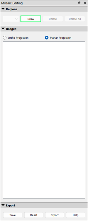
In order to edit the Orthomosaic:

1. Draw a new Region

Draw and edit as many regions as needed following:

1. On the Menu bar, click View > Mosaic Editor.
2. On the Menu bar, click Mosaic Editor > Mosaic Editing.

3. On the sidebar, in the section Regions, click Draw.

PIX4Dmapper_Mosaic_Editor_Tool.png

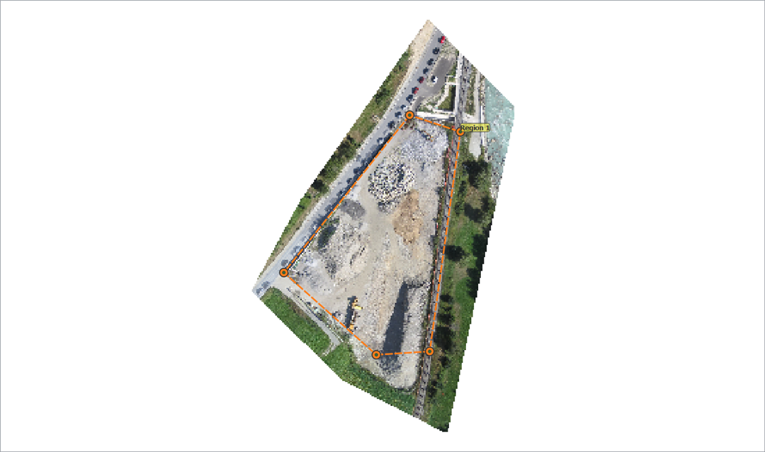
3. On the Mosaic View, left-click to insert the vertices of the region, right-click to draw the last vertex, and close the polygon.
4. (optional) Edit the shape of the region: left-click over a vertex while dragging it to the new position.

PIX4Dmapper_Mosaic.png


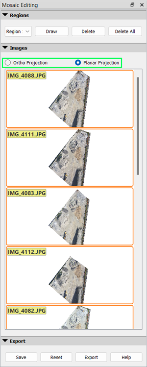
5. (optional) Change the projection selected for the region:

5.1 On the sidebar, in the section Images, select Ortho Projection or Planar projection.

PIX4Dmapper_Mosaic_Editor_Tool_Projection.png

 
Note: 
  • Ortho projectionThe Ortho projection preserves distances and can be used for mosaics dedicated to measurement applications.
  • Planar projection: The planar projection does not preserve distances, but has fewer distortions than the Ortho projection on sharp transitions such as building edges. Therefore it is not recommended to use planar images for mosaics dedicated to measurement applications. Its basic use is to improve the visual aspect of the Orthomosaic.

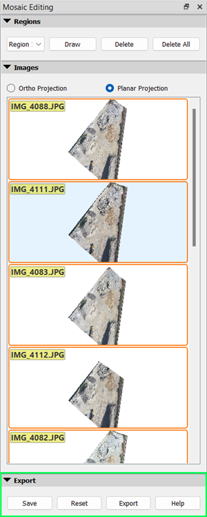
5.2. Select an image in Planar Projection or select one or multiple images in Ortho Projection. If multiple images are selected, they will be blended together.

It is possible to undo the changes:

    • Reset the displayed Mosaic. The last saved and exported Edited Mosaic will be displayed. 
 
Note: To refresh the displayed Mosaic it is needed to aggressively zoom in/out or close and open the project again.
    • Reset the displayed Mosaic by using the DSM and Orthomosaic outputs filesOn the sidebar, in the section Export, click Reset.
 
Note: The Reset option does not reset the drawn regions.


2. Save the changes

1. On the sidebar, in the section Export, click Save.

 
Note: After saving the drawn regions can be deleted without affecting the saved edits. The edits will be lost only if the project is closed.


3. Export the saved Edited Mosaic into new outputs

1. On the sidebar, in the section Export, click Export.

PIX4Dmapper_Mosaic_Editor_Tool_Reset.png


Warning: 
  • Ensure that all changes to be exported are saved.
  • Exporting the Edited Mosaic will overwrite all the mosaics generated in step 3.
  • The Grid DSM as well as the different orthomosaic formats (GeoTIFF, Google Maps Tiles, etc.) will be regenerated if selected in the processing options.


Was this article helpful?
10 out of 19 found this helpful

Article feedback (for troubleshooting, post here instead)

24 comments

  • Susan Myers

    Is it possible to snap to existing region vertices when creating regions?  The vertices of existing regions highlight with a yellow circle when hovering above them, but although I might click at that yellow point, zooming in to inspect - the new vertex does not snap to the highlighted vertex.  Is there a way to snap to it?

  • Avatar
    Beata (Pix4D)

    Hello Susan,

    Unfortunately, it is not possible to snap the vertices in the Mosaic Editor. However, I'll share your suggestion with our team to consider adding this feature in the future.

    Cheers! 

  • Adam Barbe

    Hi there, I'm new to this.  

    My Ortho image has this strange color for one of the tiles.  Can I redo just a few images that make up a single tile?  See screenshot. 


    Edited by Adam Barbe
  • Daniel (Pix4D)

    Hi Adam,

    That is very weird.

    I am afraid that It is not possible to process just a few images, Step3 has to be run again.

    You could use a processing area and process a part of the project only but the previous ortho would be overwritten.

    I wonder why that is happening, how do the original images look like?

    If you go to Contact Support and open a ticket, we could try to find the reason for the failure.

    Thank you very much.

    Edited by Daniel (Pix4D)
  • Drew Gonsalves

    Pix4d,

    Does the mosaic editor affect reflectance map outputs? For Micasense imagery I would like to edit the mosaic and have these changes affect the reflectance images. Are the reflectance tifs generated and found in the folder '<project>/4_index/reflectance/ (with names such as *_transparent_reflectance_blue.tif)' affected by the mosaic editor changes? I am able to modify the mosaics of each of the (5) bands of the Micasense camera -> save -> export in the Mosaic Editor which produce files found in <project>/3_dsm_ortho/2_mosaic/*transparent_mosaic_blue.tif'. However, after completing the changes to the mosaic I do not see these changes reflected in the viewer in the tab Index Calculator nor do I see the mosaic modifications appear in the reflectance*.tif images. Thank you.


    Drew

  • Avatar
    Momtanu (Pix4D)

    Hi Drew,

    Edited reflectance maps is not possible with the mosaic editor, because the reflectance map and the orthomosaic are independent (article).So changing the orthomosaics will not have any impact on the reflectance maps. Also, as the reflectance map contains the true value of the pixel, any improvement of this should come from the densified point cloud.

    Edited by Momtanu (Pix4D)
  • Andrew Chafer

    I have a shapefile for my project extents.  Is it possible to import this shapefile and use that figure to trim the orthomosaic?

  • Avatar
    Momtanu (Pix4D)

    Yes, you can import the shapefile as your processing area. If you have already processed all the steps, just import it and process step 3 only (uncheck the other steps). Have a look here: https://support.pix4d.com/hc/en-us/articles/202560179-How-to-select-draw-the-Processing-Area

  • Sibu Jacob

    Can you please explain using mosaic editor how we can extend a part of the image to the white patches ( IMAGE MISSING PORTIONS) which were not processed using mosaic editor. 

    Edited by Sibu Jacob
  • Daniel Ierodiaconou

    Hello,

    I want to Clip/Crop both the Orthomosaic and DSM to remove to data outside of the accurate mapping region (the edges where there is no overlap), so I can provide just the spatially accurate data to my client. Can I Clip/Crop the extent of the DSM and Orthomosaic so I don't have the jagged edges? I tried in QGIS and ArcMap, but the files became extremely large.

  • Avatar
    Momtanu (Pix4D)

    @Daniel, You can draw a processing area (https://support.pix4d.com/hc/en-us/articles/202560179-How-to-select-draw-the-Processing-Area) and process only step 3 again. Uncheck step 1 and 2.

  • Avatar
    Momtanu (Pix4D)

    Sibu, if there are Nan values in the pixels (missing), you cannot edit the mosaic and extend or add pixels values from other parts to that region. Pix4D does not have that feature yet.

  • Sibu Jacob

    Hi Again !!

     Can you please advice how do we calibrate the uncalibrated images. If there is such a provision will the RED dots ( uncalibrated image)  change  to GREEN / BLUE DOTS ( calibrated image) 

    The tutorial provided in the Pix4D manual doesn't provide the correct English language to mark which images and how many tie points per image to convert them to calibrated image. Also there is no video available on the internet which shows how to calibrate an  uncalibrated image  through a sample demo. This is the most important part of any post processing image software :))


    Can you please help here !!


    thank you

  • Avatar
    Momtanu (Pix4D)

    Hi Sibu,

    It is possible to calibrate the images manually, but this is a time consuming process and it is not indicated when there are too many uncalibrated images. 
    In such cases it is preferable to try to find the reason that the images are not getting calibrated. Maybe the problem is the terrain type in this part of the project area.
    For more information about possible reasons that the images are not getting calibrated and possible solutions you can take a look here: https://support.pix4d.com/hc/en-us/articles/202558689#label101

    If the number of uncalibrated images are low, you can calibrate as you already know. The number of tie points must be minimum 3. The Tie Points should be marked on the uncalibrated image and at least 2 calibrated images. It should not be marked only on uncalibrated images.

    If anything in the article https://support.pix4d.com/hc/en-us/articles/202560189-How-to-manually-calibrate-uncalibrated-Cameras-in-the-rayCloud is unclear, let me know, we will help. Also, thank you for your suggestion about the video, I will add it to our list. Also have a look here: https://community.pix4d.com/t/calibrating-uncalibrated-cameras/2816/10

  • Omal Vindula

    if there is a tree in the middle of a stockpile, how do i calculate the volume?

  • Avatar
    Momtanu (Pix4D)
  • Owen Jenkins

    When attempting to export a thermal mosaic which has been edited to change the colour pallet, the exported tif reverts back to the original grey scale. Is it possible to export the mosaic as a radiometric jpeg?

    Many thanks


  • Avatar
    Momtanu (Pix4D)

    Owen, you can export the colored index map as jpeg and geotiff. It is not possible to export as rjpeg. This is because we convert the rjpeg to tif and use the radiometric information in the rjpeg. We then use the tif for processing. 


  • LIEB Julien

    Hello,

    Can I export a voronoi map with the reference of picture used for of each polygon?

    Thank you,

    Julien

  • Avatar
    Momtanu (Pix4D)

    Hi Julien,

    Can you explain a bit more? What Voronoi map do you need? 

  • Julien Lieb

    I need a .shp mosaic layer (over my orthomosaic) like the one I enclosed that shows wich picture(s) were used for each part of the mosaic.

    Is it clear?

    Each red dot should be the reference of one or more image.

  • Avatar
    Momtanu (Pix4D)

    Hi Julien, Unfortunately, that is not generated in Pix4D. However, there is a bingo file that might be of your interest: https://support.pix4d.com/hc/en-us/articles/203590305-What-is-the-bingo-file-generated-during-Initial-Processing

     
  • Julien Da Silva Martins

    Hi Pix4D,

    Sorry in advance for my english mistakes.

    Is it possible to change the background color of the orthomosaïc (in white for exemple) ? 

    For my clients it's preferable to have a orthomosaïc in Autocad with a white background.

    Thank's.


  • Fernanda Bosmediano

    Hi Vincent,

    Yes, it is possible, please make sure that GeoTIFF without Transparency option is unchecked as shown in the figure below. This might be the reason that you are not getting a transparent background for the orthomosaic and the individual tiles. 


    You can also verify that using your folder name. If the folder name is in project_name_mosaic_group_name format than you didn't select the transparency option


Article is closed for comments.