IN THIS ARTICLE
Project coordinate system when processing images
Project coordinate system when uploading outputs
Manual project coordinate system definition
Choosing the correct workflow to define the project coordinate system
Licenses: This article is valid for PIX4Dcloud Starter and PIX4Dcloud Pro licenses (formerly PIX4Dcloud Advanced).
Roles: Only Owners, Managers, and Editors can create and process datasets in PIX4Dcloud.
Project coordinate system when processing images
When images are processed in PIX4Dcloud, the project coordinate system is defined during Step 3 of the dataset creation wizard.
-
The coordinate system is selected in the Output coordinate system section.
-
PIX4Dcloud automatically proposes a default coordinate system based on the image geolocation, which is suitable for most use cases.
For more information, see: New dataset Processing options Output coordinate system - PIX4Dcloud.
For more information, AutoGCPs detection functionality - PIX4Dcloud Pro.
Project coordinate system when uploading outputs
When a project is created in PIX4Dcloud only to visualize existing outputs (such as an orthomosaic, DSM, NDVI, point cloud, or 3D mesh), the project coordinate system is automatically defined by the first georeferenced output uploaded.
-
All subsequent outputs must use the same coordinate system.
-
Mixing outputs with different coordinate systems may result in misalignment.
For more information, see: New dataset Dataset creation Upload outputs - PIX4Dcloud.
Manual project coordinate system definition
A project coordinate system can be defined manually in the following cases:
-
The project is empty and no outputs have been uploaded.
-
The project contains outputs without an embedded coordinate system, such as:
-
IFC files
-
3D mesh files
-
Outputs missing CRS information (e.g. orthomosaic, DSM, NDVI, or point cloud without a defined coordinate system)
-
To manually define the project coordinate system:
-
In Drive, click New dataset.
-
Select Upload processed results.
-
Click Create to generate an empty project in PIX4Dcloud.
-
Click Set CRS to manually define the project coordinate system.
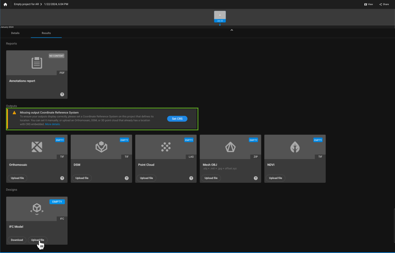
Information: Once the project coordinate system is manually defined, PIX4Dcloud expects all subsequently imported outputs and annotation files to be georeferenced in the same coordinate system.
Choosing the correct workflow to define the project coordinate system
The table below summarizes how the project coordinate system is defined in PIX4Dcloud based on how the project is created and which data is available.
| Project scenario | How the project is created | Coordinate system definition | Notes |
| Images are processed directly in PIX4Dcloud | Upload images and start processing | Defined in Step 3 – Output coordinate system of the dataset creation wizard | A default coordinate system is automatically suggested based on image geolocation |
| Images are processed with GCPs (PIX4Dcloud Pro) | Upload images and GCPs and start processing | Defined by the GCP coordinate system | The output coordinate system must match the GCP coordinate system |
| Outputs are uploaded for visualization only | Upload processed outputs (no image processing) | Defined by the first georeferenced output uploaded | All uploaded outputs must use the same coordinate system |
| Outputs include files without CRS (e.g. OBJ, IFC) | Upload processed results | Must be manually defined before or during upload | Required when outputs do not contain embedded CRS information |
| Empty project (no images or outputs) | Create dataset → Upload processed results | Manually defined using Set CRS | Useful for preparing a project before uploading outputs |
| Mixed outputs with different CRS | Upload processed results | Not supported | All outputs must share the same coordinate system |