The image acquisition plan depends on the:
- Type of terrain / object to be reconstructed.
- Ground Sampling Distance (GSD): The GSD required by the project specifications will define the distance (flight height) at which the images have to be taken. For example a GSD of 5 cm means that one pixel in the image represents linearly 5 cm on the ground (5*5 = 25 square centimeters).
- Overlap: The overlap depends on the type of terrain that is mapped and will determine the rate at which the images have to be taken.
A bad image acquisition plan will lead to inaccurate results or processing failure and will require to acquire images again.
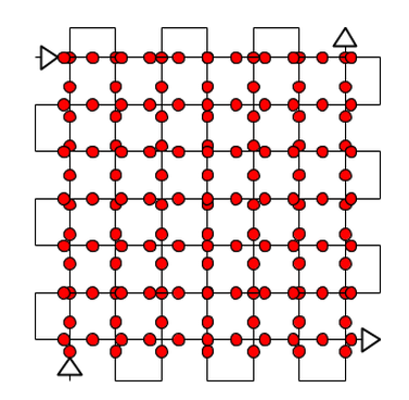
General caseFor most cases it is recommended to acquire the images with a regular grid pattern. The recommended overlap is at least 75% frontal overlap (with respect to the flight direction) and at least 60% side overlap (between flying tracks). The camera should be maintained as much possible at a constant height over the terrain / object to ensure the desired GSD.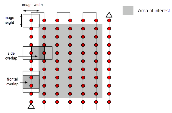
The overlap and flight height have to be adapted depending on the terrain.
For flat agriculture fields, at least 80% frontal and side overlap is recommended. For forest, dense vegetation areas it is recommended to increase the overlap to at least 85% frontal and side overlap and fly higher so that it is easier to detect similarities between overlapping images. Projects with thermal images require at least 90% frontal and side overlap.
For projects with multiple flights there should be overlap between the different flights and the conditions (sun direction, weather conditions, no new buildings, etc.) should be similar.
Building reconstructioncFor the reconstruction of a building a circular flight plan is recommended.
- Fly around the building a first time with a 45° camera angle.
- Fly a second and third time around the building increasing the flight height and decreasing the camera angle with each round.
- It is recommended to take one image every 5 to 10 degrees to ensure enough overlap, depending on the size of the object and distance to it. More images should be taken for shorter distances and larger objects.
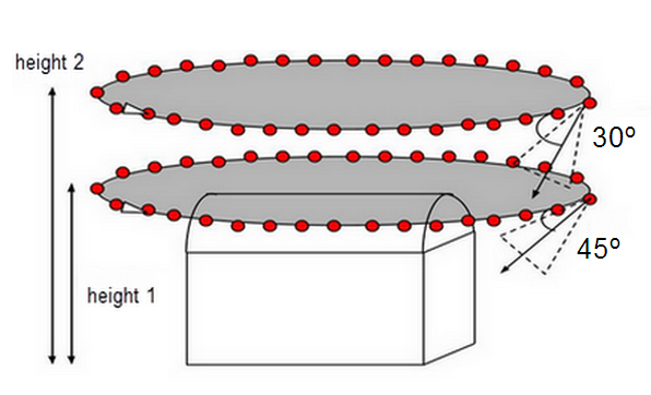
Note: The flight height should not be increased more than twice between all flights, as different heights lead to different GSD.
City reconstruction - visible facadesThe 3D reconstruction of urban areas requires a double grid image acquisition plan, so that all the facades of buildings (north, west, south, east) are visible on the images. The overlap should be the same as in section General Case.
For the facades to be visible, the images should be taken with an angle between 10o and 35o (0° - the camera is looking down).