Fallow weed detection
When weeds are detected in a fallow field, vegetation indices are generally used to differentiate the green weeds from the bare soil or previous crop residue. These indices can be derived from both RGB and multispectral (MSP) cameras. Satellite imagery from Sentinel-2 is discarded for weed identification due to its low resolution (10 meters per pixel).
Image resolution/flight height
Orthomosaics with a GSD between 2 and 3 cm are ideal for fallow weed detection. If weeds occur in larger patches or zones, a lower resolution of GSD between 4 and 5 cm is generally acceptable.
RGB vs. Multispectral in fallow weed detection
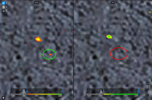
At the same flight altitude, multispectral images, even with lower resolution, help to better differentiate weeds.
- Multispectral images are superior to RGB for detecting green weeds in fallow fields, especially when using the NDVI and OSAVI indices.
- RGB-based methods (VARI, TGI) are less reliable due to "noise," but are much more practical, making multispectral data preferable for accurate weed identification
GSD MSP: 5 cm/pixel.
GSD RGB: 3 cm/pixel.
Examples:

Green-on-Green
Recent research indicates that high-resolution RGB cameras are particularly effective for green-on-green weed detection. Integrating RGB imagery with advanced identification tools like the Magic Tool enables reliable detection of weeds growing within crops, pastures, and other vegetative environments.
For accurate detection, one must fly when the weeds are visually distinct from the crop (e.g., by color, height, and diameter).
The Magic Tool provides identification for all weeds that are visually different from the crop, but it does not classify them by type.
Examples:
- Sorghum halepense in wheat:

-
Weeds emerge during the early stages of crop growth:

Recommended camera and resolutions
| Fallow | Green on green | |||
| Crop stalls & residues | Plowed field | Distinct color difference between crops and weeds. | Minimal color difference between crops and weeds. | |
| Camera | MSP | RGB | RGB | RGB |
| Recommended tool | Index + Operation | Index + Operation | Magic Tool + Operation | Magic Tool + Operation |
| Resolution | Around 3cm. Weed diameter should be covered by 4 pixels. |
Around 2cm. Weed diameter should be covered by 4 pixels. |
1.5 to 3 cm. Weed diameter should be covered by 16 pixels for the Magic tool to detect it. |
1.5 cm or less. Weed diameter should be covered by 32 pixels for the Magic tool to detect it. |
Flight heights and resolutions for certain drones
DJI M3M - RGB Camera
120m - 3.2 cm/px
80m - 2.1cm/px
40m - 1 cm/px
20m - 0.5 cm/px
P1 35mm
120m - 1.5 cm/px
80m - 1 cm/px
40m - 0.5 cm/px
20m - 0.25 cm/px
The recommended parameters are provided for guidance purposes only and do not represent guaranteed performance for our software.