PIX4Dsurvey allows combining the extracted information of photogrammetry projects from PIX4Dmapper, PIX4Dmatic, or PIX4Dcloud, together with point clouds from any source. This way, data from different sources are combined in even more complete ways, and in addition, possibilities of multiple point clouds are unified in a single project by respecting the processing that is already done.
PIX4Dsurvey allows the combination and alignment of multiple photogrammetry projects purely based on their geospatial referencing information so that all components of the project (point cloud, images, and their relationships) are retained.
How to import different projects into PIX4Dsurvey
PIX4Dsurvey allows the import of PIX4Dmapper and PIX4Dmatic projects, .dxf files, as well as external point clouds. After importing a project into PIX4Dsurvey, multiple photogrammetry projects can be added to this single project.
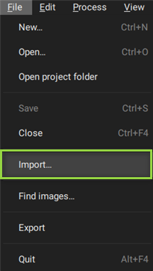
To combine several photogrammetry projects, any project can be imported into an existing PIX4Dsurvey project by selecting File > Import or drag-and-drop to include the .p4d / .p4m or other Inputs supported by PIX4Dsurvey.
Importing a .p4d / .p4m project or a .las / .laz file to an empty PIX4Dsurvey project sets the project reference frame to the reference frame of the imported project.
When trying to combine several projects in a single PIX4Dsurvey project, have in mind that:
- Projects with a different coordinate system than the pre-existed PIX4Dsurvey project can be imported and transformed into the predefined coordinate system of the pre-existing PIX4Dsurvey project.
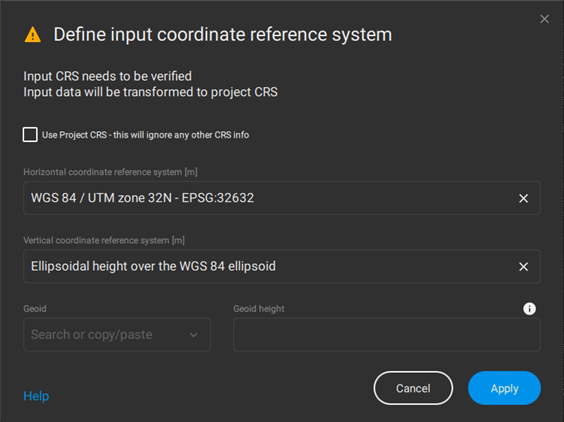
- If the project coordinate system is not fully recognized, then the input coordinate system definition dialog (Define input coordinate reference system pop-up window) is displayed, and the coordinate system of the imported project can be selected.
- In case .las / .laz files with different coordinate systems from the pre-existing PIX4Dsurvey project are being imported, the input coordinate system definition dialog (Define input coordinate reference system pop-up window) is displayed, and the coordinate system of the imported project can be selected.