The Color-based selections in PIX4Dsurvey allow for an easy selection of objects and other features based on their color. The Road selection is more specific for road surfaces and thus has tailored parameters for these features.
IN THIS ARTICLE
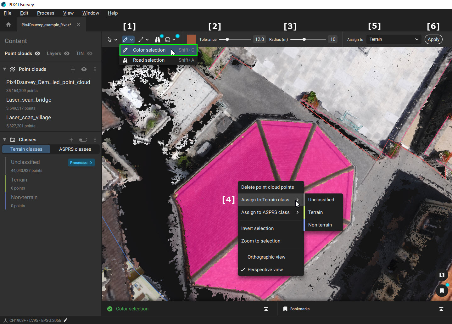
Color selection
Video: Sorting by color with Color Selection in PIX4Dsurvey. This features helps better understand the pointcloud and refine the classification by defining a point radius and color tolerance in order to select the points needed.
The Color selection tool selects points based on color, color tolerance, and radius.
Access:
- In the Color-based selections tool drop-down menu, click
 Color selection, or
 - Use the Shift + C shortcut.
To use the tool:
- Select the Color selection tool [1].
- Click on a point in the dense point cloud.
Tip: The color of the selected point is the base for the algorithm. Ensure it represents the area you want to select.
- Adjust the Tolerance [2]:
- A lower Tolerance value narrows down the colors for selection. Only points that have a similar color as the selected point are detected.
- A higher Tolerance value extends the color range included in the final selection.
- Adjust the Radius [3]. It represents the maximum distance from the clicked point.
Note: Once a point is selected, the adjustments in Tolerance [ 2] and Radius [ 3] are visible interactively in the pink selected area.
- Once satisfied with the selection, right-click in the 3D view [4] to:
- Delete points, or
- Assign points to the desired class.
- It is also possible to assign points to the desired class by selecting the class from the toolbar [5] and clicking on Apply [6]
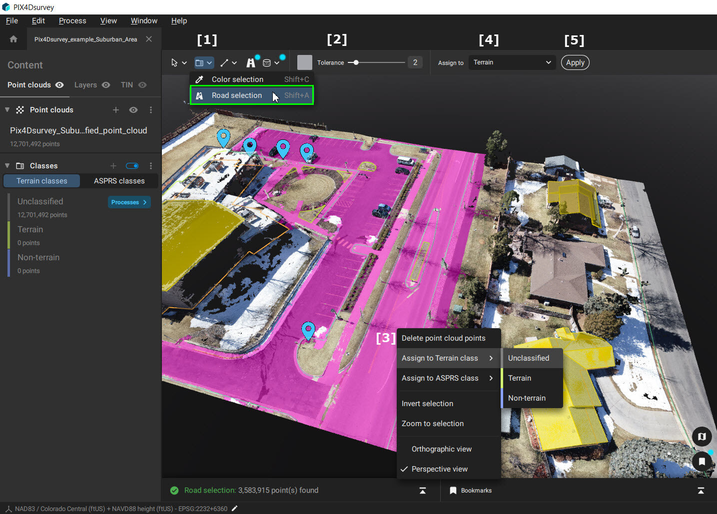
Road selection
The Road selection tool selects points based on their color, color tolerance, elevation, and continuity.
Access:
- In the Color-based selections tool drop-down menu, click
 Road Selection, or
 - Use the Shift + A shortcut.
To use the tool:
- Select the Road selection tool [1].
- Click on a road in the dense point cloud.
Tip: The color of the selected point is the base for the algorithm. Ensure it represents the road you want to select.
- Adjust the Tolerance [2]:
- A lower Tolerance value narrows down the colors for selection. Only points that have a similar color than the selected point are detected.
- A higher Tolerance value extends the color range included in the final selection.
Note: Once the road is selected, the adjustments in Tolerance [ 2] are visible interactively in the pink selected area.
- Once satisfied with the selection, right-click in the 3D view [3] to:
- Delete points, or
- Assign points to the desired class.
- It is also possible to assign points to the desired class by selecting the class from the toolbar [4] and clicking on Apply [5]
Note: The slope and the spatial continuity are also taken into account by the algorithm. These parameters cannot be modified.
- If the road slope has a significant change, the algorithm will not consider it as part of the same road.
- Roads will be selected only if there is a spatial connection. Disconnected roads will not be selected and must be selected in a second step.