IN THIS ARTICLE
Get started with real data
Vegetation indices
My first vegetation index map - Winter wheat
Variable rate nitrogen fertilization - Winter wheat
RGB dataset - Winter wheat
Weed detection
Weeds on fallow detection (Green on Brown)
Crop weeds detection (Green on Green)
Damage detection
Measuring lodging (wind damage) - Winter wheat
High resolution satellite data
High resolution satellite example project
Get started with real data
Utilizing real data showcases the capabilities of PIX4Dfields software and provides valuable insights into the requirements for effectively collecting your data.
Register for a 15-day trial license and download any example use case for free to explore PIX4Dfields functionalities with real data.
Not sure where to begin? Follow the instructions below to create your first project.
Important: These datasets may only be used for personal or professional training. For commercial or promotional use, “Courtesy of PIX4D / pix4d.com” must be displayed and all the text linked to pix4d.com. For more information on usage, contact our marketing team.
My first vegetation index map - Winter wheat
In this example use case, we describe the step-by-step process of using drone images to obtain maps. These maps are so-called orthomosaics, which can be created from RGB or multispectral images.
The goal of this project is to obtain a Normalized Difference Vegetation Index (NDVI) index map of a field using the DJI Phantom 4 multispectral camera that captures Green, Red, Blue, Red edge, and NIR wavelengths.
The NDVI scale ranges from -1 to +1. This scale is designed to represent different types of land cover and vegetation health or density.
In the example below, Greener areas indicate dense green leaves typically associated with healthy, vigorous vegetation. Red areas indicate barren areas of less vigorous crops, or minimal vegetation.
 |
|
|
Dataset size
|
5 GB |
| Average Ground Sampling Distance (GSD) | 6.2 cm / 2.44 in. |
| Area covered | 46.5 ha / 114 acres. |
| Image acquisition plan | 1 flight, grid flight plan. |
| Drone and camera |
DJI Phantom 4 Multispectral, Multispectral camera. Spectral bands:
|
| Reflectance panel/target | Micasense |
| To access the tutorial and the images, please visit: My first vegetation index map - PIX4Dfields |
|
Variable rate nitrogen fertilization in wheat
The goal of this project is to obtain an NDVI index map of a field using the Sequoia camera that captures Green, Red, Red edge and NIR wavelengths.
 |
|
|
Dataset size
|
4 GB |
| Average Ground Sampling Distance (GSD) | 10.0 cm / 3.94 in |
| Area covered | 44.9 ha / 110.95 acres |
| Image acquisition plan | 1 flight, grid flight plan. |
| Drone and camera |
Parrot Sequoia, Multispectral camera Spectral bands:
|
| Reflectance panel/target | Not present |
| Download example images | |
The downloaded folder contains the following files and folders:
- Images: Red, Green, Red edge and NIR images in TIFF format.
- Boundary: project file that can be opened in PIX4Dfields.
- To begin processing the dataset, follow the guide My first vegetation index.
RGB dataset of wheat
The goal of this project is to obtain a VARI index map of a field using the S.O.D.A camera that captures Red, Green, Blue wavelengths.
 |
|
|
Dataset size
|
3 GB |
| Average Ground Sampling Distance (GSD) | 2.80 cm / 1.10 in |
| Area covered | 44.9 ha / 110.95 acres |
| Image acquisition plan | 1 flight, grid flight plan. |
| Drone and camera | senseFly S.O.D.A., RGB camera |
| Reflectance panel/target | Not relevant |
| Download example images | |
The dataset can be downloaded here.
The downloaded folder contains the following files and folders:
- Images: Red, Green, Blue images in JPG format.
- Boundary: project file that can be opened in PIX4Dfields.
Weeds on fallow detection (Green on Brown)
In this example use case, we describe how to detect fallow weeds, also known as green-on-brown detection. A simple RGB camera was used instead of a multispectral camera. This means that most consumer drones can selectively detect and allow spraying weeds while saving up to 90% on herbicides.
 |
|
|
Dataset size
|
3.5GB |
| Average Ground Sampling Distance (GSD) | 1 cm / 0.39 in |
| Area covered | 6.54 ha / 21.25 acres |
| Image acquisition plan | 1 flight at 50mts, grid flight plan. |
| Drone and camera |
DJI Mavic 3 Multispectral, RGB camera. |
| To access the tutorial and the images, please visit: Weeds on fallow detection (Green on Brown) - PIX4Dfields |
|
Crop weeds detection (Green on Green)
PIX4Dfields supports green-on-green detection through high-resolution imagery and the Magic Tool. Follow this article to detect weeds efficiently within crop and pasture fields, saving up to 90% on herbicide applications.
 |
|
|
Orthomosaic size
|
2.66 GB |
| Average Ground Sampling Distance (GSD) | 0.5 cm / 0.19 in. |
| Area covered | 1.75 ha / 4.37 acres. |
| Image acquisition plan | 1 flight, grid flight plan. |
| Drone and camera |
DJI Mavic 3 Multispectral, RGB camera |
| Reflectance panel/target | Not applicable |
| To access the tutorial and files, please visit |
|
Measuring lodging (wind damage) in a wheat field
The goal of this project is to detect lodging in a winter wheat field with the help of the Magic Tool. Detecting and quantifying the extent of crop damage is essential for filing insurance claims.
 |
|
|
Orthomosaic size
|
1.66 GB |
| Average Ground Sampling Distance (GSD) | 3.53 cm / 1.39 in |
| Area covered | 13 ha / 32 acres |
| Image acquisition plan | 1 flight, grid flight plan. |
| Drone and camera | RGB camera |
| Reflectance panel/target | Not applicable |
| Download example Orthomosaic |
|
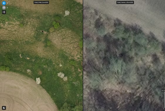
High resolution satellite example project
Since PIX4Dfields 2.12, support for high resolution satellite imagery has been introduced directly in PIX4Dfields projects. This data can be combined with drone orthomosaics to extend coverage, monitor larger areas, or compare historical and current conditions within the same PIX4Dfields workflow. Download this PIX4Dfields project to explore an example dataset and see how high-resolution satellite imagery can be visualized and analyzed.
|
|
|
|
Project size
|
2.7 GB |
| Ground Sampling Distance (GSD) |
Drone orthomosaics: 2 to 5 cm (0.8 to 2 inches) |
| Spectral bands |
|
| Download example Project |
|
- Double-clicking on the file, ensuring PIX4Dfields is closed.
- Importing it within PIX4Dfields, go to Settings, Import projects, and select the .p4z file.