Once the site calibration parameters have been computed, they can be used in projects where the image geolocation has been acquired using precise GPS, such as RTK GPS, and in which no GCPs are used. The output coordinate system should be in an arbitrary coordinate system. For more information about how to compute the site calibration parameters for GCPs in an arbitrary coordinate system: How to compute the Site Calibration for GCPs in an Arbitrary Coordinate System.
To use site calibration parameters:
1. Create a project using images with geolocation in a known coordinate system: Step 2. Creating a Project.
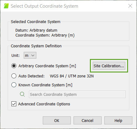
2. On the Menu bar, click Project > Select Output Coordinate System.
3. In the section Coordinate System Definition, click the Unit dropdown list to set the units of the coordinate system (meter [m] or international foot [ft]).
4. Select Arbitrary Coordinate System [unit].
5. Select the box Advanced Coordinate Options and click Site Calibration...
The pop-up Site Calibration Parameters appears. The section Projection defines the known coordinate system involved in the transformation.
6. On the pop-up Site Calibration Parameters, select Enable Site Calibration and click Import....
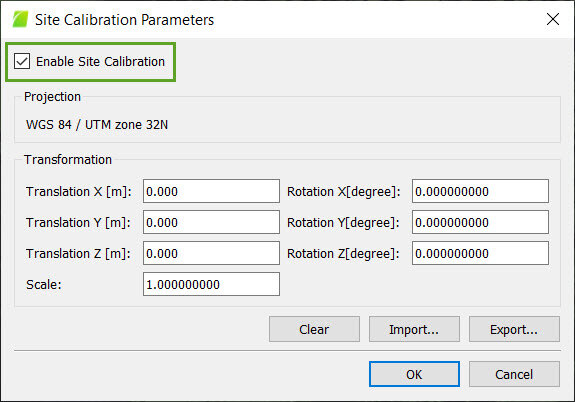
7. On the pop-up Select Import File, navigate to the file that has been previously exported. Select it and click Open. The site calibration transformation is loaded.
8. On the pop-up Site Calibration Parameters, click OK.
9. On the pop-up Select Output Coordinate System, click OK.
10. Process the project. For more information: Step 4. Processing.