Regions is a feature used to estimate indexes over specific areas of the reflectance map, that later can be used to generate a prescription map for that specific area. This article explains how to create, delete, import, export, and manage existing Regions in PIX4Dmapper.
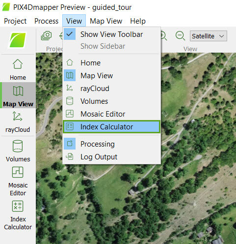
Access: On the Menu bar, click
View > Index Calculator (available once step
1. Initial Processing has been completed). The
Index Calculator sidebar is displayed on the right of the main window. For information about the sidebar's display possibilities:
Displaying bars.
IN THIS ARTICLE
Region section description
On the left part of section 2. Regions, there is an arrow that allows the user to show/hide the section by clicking on it:
-
 By default, section 2. Regions is expanded and visible.
 -
 Section 2. Regions is collapsed and hidden.
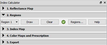
The following information is displayed:
- Selected region: Allows the user to select the region you want to edit.
- Draw: Allows the user to draw the selected region in the Index View.
- Clear: Allows the user to clear the drawn region in the Index View. Enabled if the selected region is drawn.
- Formula Status icon: Next to the button, Clear appears:
-
 The region exists and is valid.
 -
 The region has not been drawn, or the drawn area is incorrect (its edges intersect).
-
- Regions...: Opens the Region List pop-up, which allows the user to manage the regions:
- Add a new region.
- Delete an existing region.
- Edit the name of a region.
- Display some properties of the region.
- Import / export the regions.
- Help: Opens the PIX4Dmapper help.
Region button description
When the button Region... is clicked, the following pop-up appears:
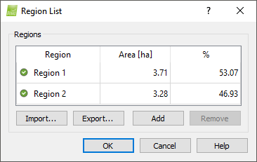
It contains the section Regions:
- Regions table: Contains the columns:
- Region: Name of the region; by double-clicking on it, it is possible to edit the name.
- Area [units]: Surface covered by the region.
- %: Percentage of the total area occupied by the region.
- Import...: Allows importing regions from a .shp files.
- Export...: Allows to export the regions to a .shp file.
- Add: Creates a new region.
- Remove: Deletes the selected region.
And the buttons:
- OK: Confirms the changes.
- Cancel: Does not save the changes.
- Help: Opens the PIX4Dmapper help.