Distortions and Artifacts in the Orthomosaic - PIX4Dmapper

Follow

Cause

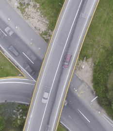
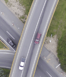
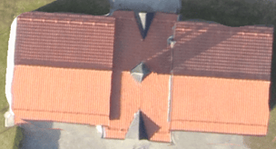
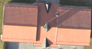
The orthomosaic is generated based on the DSM created from the Densified Point Cloud. Thereby, errors and noise present in the Densified Point Cloud will be reflected in the orthomosaic. These distortions occur because Orthorectification is used instead of Photo Stitching; for more information: Photo stitching vs orthomosaic generation.

When computing the Densified Point Cloud, the altitude of the points will not be perfectly estimated. There are always some errors and noise that are minimized for good datasets (high overlap, the good visual content of the images, use of GCPs, etc.).

These errors and noise result in altitude differences for points that are supposed to be at the same altitude, such as points that belong to the same roof edge of a building or the same edge of a bridge. This altitude difference explains the distortions that appear in the orthomosaic on building edges, bridges, etc.  

 
Note: The orthomosaic receives as input the DSM, and the DSM receives as input the point cloud. If the point cloud is noisy, the DSM may also be noisy. Make sure that the results of step 1 and the point cloud are optimal before generating the DSM and orthomosaic.

Solutions

Orthomosaic before editing Orthomosaic after editing using the Mosaic Editor


Was this article helpful?
5 out of 6 found this helpful

Article feedback (for troubleshooting, post here instead)

5 comments

  • Hu Yuan

    pix4d is famous in the world ,should be begineer user easy to operation,but,i am a user,any setup correct or wrong ,i dont know how,HELP funtion too weak,when i  finishing project, i found progress not complete ,why,i rent your monthly for year,so expensive,

    your toturial teching video,only english,i am chinese who know english ,when setup project you must let user result .but your HELP like damage machine ,.

    i very angry ,pix4d  diffcult to use,i sugesting your company ,user always stupied ,anyway easy use,chip rental ,my problem also is all user problem.

    i am a programer ,pix4d,not good software.i belive.in future you may loss your customer soon, .

    bestregards             afa8168@gmail.com                                                                                         by hung fu yuan TAIWAN

  • Holden (Pix4D)

    Hi Hung. Thanks for reaching out. If you are having issues with a project I would suggest opening a support request at support.pix4d.com. If you choose to open a support request please include a log file, quality report, and a description of the problem. 

    We are working to expand our supported languages so your feedback is helpful. Thank you.  

  • zhang haibo

    这位湾湾的兄弟,好巧哦。看见你的此番表述或者也可以称之为是抱怨牢骚之后真是让人忍俊不禁,憋出内伤。

    本人就职于祖国内地的一家甲级测绘单位,你要知到pix在内地的测绘领域简直是最低最低的入门级别软件,是所有想要和正在从事地信领域的人的最早上手的一款处理软件。它的简单易用性早在2014年至今都是人们所认可的,它优异的工具属性可以为其他更为高级复杂的处理软件例如CC、inpho、photomash等输出优秀的辅助数据,就像一位厨师手中最简单也最有效的一把刀具。

    pix4d引以为傲的就是详细的在线帮助文档,是我所接触的众多软件中最为人性化和实用化,它不像其他软件的帮助文档冗长繁杂。pix用一步步详细步骤为客户解释所有选项,和选项改变的前因后果,真是让人由衷的感动。

    我并不认为你已经翻遍了pix网站的所有帮助说明,如果可以,沉下心来,好好的去研读和练习。一味的抱怨只会让人怀疑你的能力,何况还是如此简单的一款入门软件。

    不知道你有没有看过周星驰先生的《功夫》影片,里面有这么一句话:你想学啊?我教你啊。

  • Eugenia Pylypchuk

    Hi pix4d team,
    I got to much artefacts on my resulting ortho, such as you described in this article, on buildings, bridges and other high objects. And it takes a lot of time to correct them all mannually using Mosaic editor. Wouldn't it be easier to be able to make orthomosaic using DTM, not DSM to avoid such artefacts creation? As far as I understood there is no such option.
    And do these artefacts apear just due to difference in height between ground and building roof or the top of other vertical object, or maybe due to some other reasons (noise, errors etc.)?
    Maybe you'll suggest something to reduse amount of such artefacts?

    Thanks in advance.

  • Avatar
    Aaron (Pix4D)

    Hi Eugenia, Thanks for your interest in Pix4D

    Using the DSM as the basis for the Orthomosaic is really the preferred way, you could edit the point cloud such that all data that was not Ground or Road Surface was moved to the disabled group, then the DSM would really only reflect those pixels normally shown in the DTM (Ground and Road Surface), however, I don't believe the resulting Orthomosaic would look very good as the Buidling, Human made objects and High veg would not have any supporting 3D data for them.  I would suggest increasing the overlap among your images to help reduce artifacts and you could increase the Minimum number of matches as well.  I hope these suggestions help, lets us know if you have questions regarding a specific project.

    Regards,

    Aaron Woods

Article is closed for comments.