This article is a guide on how to change the measurement unit on a PIX4Dmapper's project.
To change the measurement units of a project:
A project that does not have GCPs but has image geolocation
To get the measurements in feet, the suitable output coordinate system needs to be defined. There are the following options:
- Select a Known Coordinate System that uses feet (International Foot or U.S. Survey Foot). For more information: Menu Project > Select Output Coordinate System.... In this case all measurements will be in feet and the outputs will be georeferenced in a known coordinate system.
Important: The selected coordinate system must be a known system for the area to be mapped. For example, if the area is located in central Colorado, the system should be NAD83 / Colorado Central (ftUS).
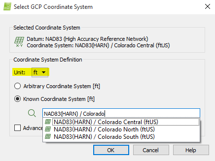
Note: PIX4Dmapper's database contains coordinate systems in meters as well as in feet (International Foot or U.S. Survey Foot). Make sure that the ft unit is selected in order to see the list of the feet coordinate systems.
- Select an Arbitrary Coordinate System, setting the unit to feet (ft). For more information: Menu Project > Select Output Coordinate System.... In this case all measurements will be in International Feet.
A project that has GCPs
Make sure that the GCPs are in a coordinate system that uses feet (International Foot or U.S. Survey Foot). To set the correct coordinate system for the GCPs: How to select / change the Image / GCP / Output Coordinate System.
Note: PIX4Dmapper's database contains coordinate systems in meters as well as in feet (International Foot or U.S. Survey Foot). Make sure that the ft unit is selected in order to see the list of the feet coordinate systems.