Error estimation in volume calculation - PIX4Dmapper

Follow

This article explains how PIX4Dmapper estimates the error of a volume calculation.

Important: In order to understand the concepts below in this article, please first read the following article about how PIX4Dmapper calculates the volume: How PIX4Dmapper calculates the Volume.

PIX4Dmapper estimates the error of a volume calculation. To calculate the error of a volume, the error for each cell of the volume has to be computed first.


PIX4Dmapper volume calculation of a cell
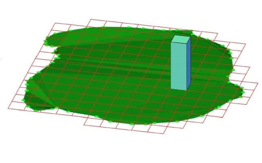
Figure 1. Volume of one cell


The altitude (Z) of a 3D point is computed with an accuracy of 1 to 3 times the ground sample distance (GSD). The average error for the height of each 3D point is 1.5 times the GSD. Since each cell of the volume base has a width and a length equal to the GSD, the error in the X and Y directions is estimated to be 0.

The error for one cell of the volume is given by:

error in X direction (length) = 0 cm.
error in Y direction (width) = 0 cm.
error in Z direction (height) = 1.5*GSD.

The volume error for each cell is given by:

Ei =  L* Wi  * Zei = GSD * GSD * 1.5*GSD = 1.5 * GSD3

Where: 

Ei = the volume error of one cell.
L= the length of the cell.
Wi = the width of the cell.
Zei = the error in the Z direction of the cell.


PIX4Dmapper volume error calculation of a cell
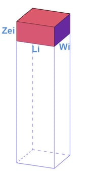
Figure 2. Volume error of a cell.


Once the volume error for each cell is calculated, the error of the Cut, Fill and Total volume are computed by summing the error of each cell. 

Cut Volume error = EC1 + EC2 +...ECN

Where:

EC1...N = Cut volume error for cell i..N. If the cell has Fill volume, then the Cut Volume error  Eis 0.


Fill Volume error = EF+ EF2 +...EFN

Where:

EF1...N = Fill volume error for cell i...N. If the cell has Cut volume, then the Fill Volume Eerror is 0.


Total Volume error = Cut Volume error + Fill Volume error


The degree of error within the volume calculations depends on the spatial resolution of the GSD:

  • It determines the accuracy with which each point's coordinates have been computed and therefore determines the volume error.
  • If the GSD is high (large value), volume calculations should not be applied.
 
Example: In a project where GSD = 50 cm, the volume calculation of an object with a 50 cm height will have a very large error. 

The volume of one cell:

V= L* Wi * H= 50= 125 000 cm3

and the volume error for this cell:

Ei =  L* Wi  * Zei = 187 500 cm3

 
Important: Choose the appropriate GSD depending on the height of the volume to be calculated. For short objects, a small GSD value (high spatial resolution) is recommended. This can be achieved by flying lower or by using a narrow focal length.
  • Lower volume accuracy should be expected for objects where few 3D points have been computed. The error estimation of PIX4Dmapper does not take this into account. One way to increase the accuracy of the object's volume is to increase the overlap.
  • If the volume error is higher or lower than 1.5*GSD then the formula to calculate the volume error of each cell has to be adjusted.  
 
Example: For a project with GSD = 5 cm PIX4Dmapper estimates volume error of Ei = 1.5 * GSD3 = 187.5 cm3. However, if it is considered that the Zei (the error in the Z direction of the cell) is 10 cm, then the volume error of each cell is equal to:
 
 
Ei = Li * Wi * Zei = GSD * GSD * 10 cm = 250 cm3.


Was this article helpful?
16 out of 24 found this helpful

Article feedback (for troubleshooting, post here instead)

7 comments

  • Dominic Fillion

    Hello, 

    I am having some issues while trying to calculate the volume, all 4 files (.obj, .mtl, .xyz, .jpeg) have been uploaded. 
    It's a manual project (no gps). All scale and axis are perfect. it just don't calculate the volume, maybe there is one step missing, I did few other manual project in the past and I was able to ajust the custom level and calculate the volume but now I am unable to do it. Thank you for your help !

    https://cloud.pix4d.com/pro/project/679776/model

  • Alice (Pix4D)

    Hi Dominic,

    The project Coordinate System is set to arbitrary, which is one of the conditions that prevent volume calculations. More information in: How to calculate volumes on the Cloud.

    In the past, you defined a projected coordinate system which is accepted from the Cloud to calculate volumes.

  • Dominic Fillion

    Hi Alice, 

    So it appear that the volume is now working, but with a big error factor as it takes the roof of the building in the volume. Is there a way to avoid that ? 

    Thank you
    https://cloud.pix4d.com/pro/project/681253/model

  • Alice (Pix4D)

    Hi Dominic,

    The volume is computed on the DSM, which in that area refers to the roof of the structure.

    The only way to get the volume estimation you want is to open the project locally, remove the points of the roof from the point cloud (assign them to the disabled group), then regenerate the DSM. At this point, you can replace the DSM for the new one.

    However, you might still have the volume from the points belonging to the wall and there are not so many points belonging to the ground. You could try to use the option 1/4 (Quarter image size, Fast) for the point cloud densification to produce a higher number of points in case of homogeneous areas.

  • Dominic Fillion

    Hello Alice, 

    I wanted to thank you very much, it might be the most helpful answer I have got since my debut on pix4d. I was always choosing the 1 scale and it was deleting so many points, it was counter intuitive for me to check the 1/4, but it really changed everything, so much that I will redo all of my former project with this option checked. 

    And then it worked for the editing with the point cloud, it's all cleaned now. At first the volume still not worked but one thing to do apparently is to uncheck the 3D texture mesh, So am I right to say that the 3D texture mesh is really only there for the look? But for any measuring matter it has to be turned off ?

    here is the improovement, thank you !!
    https://cloud.pix4d.com/pro/project/681253/model

  • Alice (Pix4D)

    Hello Dominic,

    Great improvements! I am happy to hear my suggestions were helpful!

    I understand your point. You might think that reducing the image scale leads to fewer points and less accuracy, but it's not always the case. If you want to know more about how to adjust the processing options according to your dataset, I really recommend having a look at:

    • Our documentation on Processing Options.
    • One of our Pix4Dmapper In-depth workshops. This type of workshop covers the Processing Options topic. There are upcoming ones and you can choose the one that best fits your schedule.
    • Our video tutorials.

    I am not sure I understand what you mean with your last sentence. You should be able to calculate volumes also on the 3D Mesh and with that layer turned on. You correctly uploaded the offset file together with the mesh files so that the file is georeferenced and you can calculate volumes on it.

  • Dominic Fillion

    Hello Alice, 

    Actually I discovered that I was wrong, It's just that it takes some time to the cloud to be ready to start calculating volumes after the uploads are done and even after that it indicate that the project is processed, there is a 2-3 min. delay so I was too quick on trying to do the volume calculation. Thank you for the links !

    Edited by Dominic Fillion
Article is closed for comments.