This article relates to processing large datasets in PIX4Dmapper specifically. The number of images PIX4Dmapper is capable of processing in a single project depends on the hardware resources available to the software. See our "Hardware and Pix4D" article for a detailed discussion about the role of hardware and processing.
Projects larger than 2000 images will generally require a premium workstation-class computer that has high-quality GPU and CPU along with 128GB of RAM. Projects this large can fail due to insufficient storage or RAM so it is important to ensure best practices are followed in order to avoid loss of work.
Large datasets can be taken with:
- One flight for aerial projects.
- Multiple flights for aerial projects.
- A car for terrestrial projects (mobile mapping).
- A tripod or by hand for terrestrial projects.
If the dataset consists of more than 2'000 images, it is recommended to divide the dataset into multiple projects and process them separately and then merge them.
For more information: Hardware components usage when processing with Pix4D
Two cases can be distinguished:
Having image geolocation
Not having image geolocation
When having image geolocation, the Split into Subprojects option can be used to create the multiple subprojects.
1. Create a new project that consists of all the images of the large dataset. For more information: Step 2. Creating a Project.
2. Split the project into subprojects. For more information: How to split a project into subprojects.
3. Run step 1. Initial Processing for each sub project.
4. Check the Quality Report for each subproject. For more information about how to analyze the Quality Report: Quality report specifications:
- If the quality of the reconstruction of all subprojects is good and consists of one single block, go to step 5.
- If the Quality Report indicates that there are problems with the reconstruction of one subproject, check the Quality Report Help: Quality Report Help.
5. Merge the subprojects. For more information: Merging projects.
6. (optional) Click Process > Reoptimize.
When there is no image geolocation, the dataset should be divided into subprojects manually. For more information: How to split a project into subprojects.
Having more than 3 GCPs per Subproject
1. Create a new project for each subproject. For more information: New project in PIX4Dmapper.
2. Run step 1. Initial Processing for each subproject with the same Keypoints Image Scale for all subprojects. For more information: Menu Process > Processing Options... > 1. Initial Processing > General.
3. Add at least three GCPs on each subproject. The GCPs should be homogeneously distributed on each sub project. For more information: How to include GCPs in the project.
4. Click Process > Reoptimize for each subproject.
5. Verify the Quality Report for each subproject. For more information about how to analyze the Quality Report: Quality report specifications:
- If the quality of the reconstruction is good for each subproject and consists of one single block, go to step 6.
- If the Quality Report indicates that there are problems with the reconstruction of one subproject, check the Quality Report Help: Quality Report Help.
6. Merge the sub projects. Fore more information: Merging projects.
7. (optional) Click Process > Rematch and Optimize.
Having less than 3 GCPs per Subproject
1. Create a new project for each subproject. For more information: New project in PIX4Dmapper.
2. Run step 1. Initial Processing for each subproject with the same Keypoints Image Scale for all subprojects. For more information: Menu Process > Processing Options... > 1. Initial Processing > General.
3. Add GCPs (How to include GCPs in the project) and/or Manual Tie Points (How to import and mark Manual Tie Points (MTPs)) on each subproject. The GCPs and/or Manual Tie Points should be homogeneously distributed in the common area of the subprojects. There should be at least three common GCPs and/or common MTPs marked on each subproject.
4. Click Process > Reoptimize for each subproject.
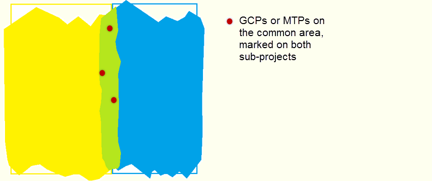
- Use the same label for the common GCPs/Manual Tie Points for all subprojects. For more information about how PIX4Dmapper treats the MTPs during merging: Manual Tie Points and GCPs in merged project.
- If less than three GCPs are used for the merged project, then they are not taken into account as GCPs.
5. Verify the Quality Report for each subproject. For more information about how to analyze the Quality Report: Quality report specifications:
- If the quality of the reconstruction is good for each subproject and consists of one single block, go to step 5.
- If the Quality Report indicates that there are problems with the reconstruction of one subproject, check the Quality Report Help: Quality Report Help.
6. Merge the subprojects. Fore more information: Merging projects.
7. (optional) Click Process > Reoptimize.