This article describes the Index Map section that is available under Index Calculator in PIX4Dmapper.
Access: On the Menu bar, click View > Index Calculator (available once step 1. Initial Processing has been completed). The Index Calculator sidebar is displayed on the right of the main window, for information about the sidebar's display possibilities: Displaying bars.

On the left part of section 3. Index Map, there is an arrow that allows the user to show/hide the section by clicking on it:
 By default section 3. Index Map is visible.
 Section 3. Index Map is not visible.

An Index Map is a single band image where each pixel value is computed using a mathematical formula combining the band information of the Reflectance Maps.
The following information is displayed:
- Name: List of available indices. The icon shown before the index name is:
 The index exists in the PIX4Dmapper index database.
 The index was created/edited by the user in this project.
 The index was created/edited by the user in another project (on the same computer) that was closed and saved.
For more information about the PIX4Dmapper index database list: PIX4Dmapper Index Database List.
- Formula: Displays the formula associated with the selected index.
- Formula Status icon: Next to the Formula, there is an icon:
 The formula is valid.
 The formula is incomplete or contains undefined band names.
- Index Status icon: If next to the Generate button, there is
 The index has been generated.
- Edit...: Grayed out when the selected index belongs to the PIX4Dmapper database. Enabled when the selected index was created by the user. Opens the Index Maps window that allows the user to edit the formula that corresponds to the selected index.
For detailed information: Menu View > Index Calculator > Sidebar > 3. Index Map > Index Map (Formula Editor).
- Indices...: Opens up the Index List window, which displays the existing indices and allows the user to add, edit, or remove indices. For detailed information: Menu View > Index Calculator > Sidebar > 3. Index Map > Index List.
- Generate: Generates a single-band GeoTiff image. Each pixel's value is computed by applying the formula to the corresponding pixel of the Reflectance Map(s). It is grayed out if the user-defined index formula is not valid.
- Help: Opens the PIX4DDmapper help.
Important: For more information about the generated files and where they are stored: Menu Process > Processing Options... > 3. DSM, Orthomosaic and Index > Index Calculator.
Section 3. Index Map also displays information about the generated index band. The following information is displayed:
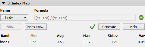
- Band: The Index Map has only one band to be displayed (band1).
- Min: Minimum pixel value.
- Avg: Average pixel value.
- Max: Maximum pixel value.
- Stdev: Standard deviation of pixel values.
- Var: Variance of pixel values.
If the selected index has not been generated, it displays: "Selected idex map not yet generated."
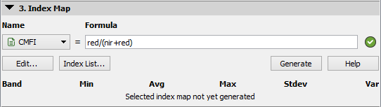
Index Map not generated
Index Map generated
Note:
- The Index Maps are calculated using some specific band(s) from one or more groups of images. Therefore, information from one or more Reflectance Maps may be used.
- If a Region/Regions is drawn, the Index Maps and Colored Index Maps will be generated only for this region/regions.
- Colored Index Maps are generated by applying the defined coloring rules to the Index Maps. They are raster files with RGB values.