The Image Geolocation section contains:
- Coordinate System: Selects the coordinate system used for the images' geolocation.
- Geolocation and Orientation: Imports/exports the coordinates and, optionally, the orientation of the images and/or the accuracy of the coordinates.
- Geolocation Accuracy: Selects the accuracy of the geolocation.
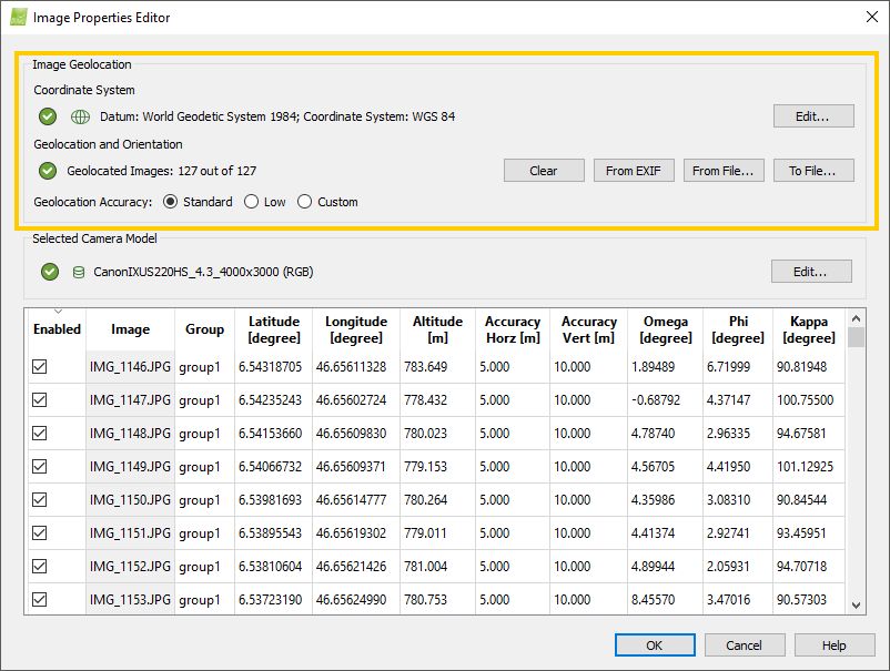
Coordinate System
- Datum: Displays the selected image datum. By default the selected datum is World Geodetic System 1984.
- Coordinate System: Represents the selected image coordinate system. By default the selected coordinate system is WGS 84.
- Vertical coordinate system or Geoid Height Above the Ellipsoid: It is displayed in parenthesis. It represents the vertical coordinate system / Geoid Height Above the Ellipsoid that will be used to convert the image height from geoidal to ellipsoidal. For more information about when to use this function: When to use the Geoid Height Above the Ellipsoid Function?.
- Edit...: Opens the Select Image Coordinate System pop-up that allows the user to change the selected coordinate system.
For more information: Select Image / GCP / Output Coordinate System .
Geolocation and Orientation
The left icon indicates the status:
 : If less than 20% images are geolocated, lower precision results are expected.
 : More than 20% images are geolocated.
The number of geolocated images is displayed next to the status indicator icon.
There are 4 options available for this section:
- Clear: Deletes the images' coordinates that are already loaded.
- From EXIF: Imports the image geolocation (coordinates) written in the EXIF data of the images if they are available.
- From File...: Imports from a file the coordinates of the images and, optionally, the orientation of the images and/or the accuracy of the coordinates using the Select Geolocation File pop-up.
- To file: Exports to a file the coordinates of the images and, optionally, the orientation of the images and/or the accuracy of the coordinates using the Export Image Geolocation pop-up.
Geolocation Accuracy
Defines the horizontal and vertical accuracy values (Accuracy Horz, Accuracy Vert).
- The horizontal accuracy (Accuracy Horz) refers to the first and second coordinates (latitude and longitude or X and Y) of the images.
- The vertical accuracy (Accuracy Vert) refers to the third coordinate (altitude or Z) of the images.
There are 3 options:
- Standard: Useful when having very accurate image geolocation. Sets the values to:
- Accuracy Horz: 5m.
- Accuracy Vert: 10m.
- Low: Useful when having non accurate image geolocation. Sets the values to:
- Accuracy Horz: 50m.
- Accuracy Vert: 100m.
- Custom: Allows to set other values or edit the accuracy of each individual image or of a group of images.
The higher the accuracy numerical value (m or ft), the less influence the image's coordinates will have in the Initial Processing compared to other images or GCPs with lower accuracy numerical values (m or ft). The accuracy is a value between 0.001 and 10'000.
To edit the accuracy of one image, double click on the corresponding cell and enter the new value: Menu Project > Image Properties Editor... > Images Table.