This step is optional but highly recommended.
>> Skip this step if no Georeferencing will be used for the images <<
PIX4Dmapper can process images both with and without geolocation. However, it is strongly recommended to know the position of the camera for at least 80% of the images to get high quality and faster results. PIX4Dmapper does not require the IMU parameters. Orientation parameters are computed during the processing.
- Images without geolocation
- Images with known position using a camera with built-in GPS tagging
- Images with known position using an external GPS logger
Images without geolocation
PIX4Dmapper can process images without geolocation. When images have no geolocation, PIX4Dmapper needs additional information to locate, scale, and correctly orient the model. Ground Control Points (Step 1. Before Starting a Project > 4. Getting GCPs on the field or through other sources (optional but recommended)) will place the model at the correct location, scale, and orient it. If no GCPs are used, then the scale (How to scale a project) and orientation (How to orient a project) constraints can be used.
Images with known position using a camera with built-in GPS tagging
Most of the major manufacturers push their weight behind GPS tagging; Panasonic, Sony, and Canon are some well-known camera manufacturers that have released such cameras so far. Most of these cameras save the GPS coordinates in the images' EXIF data. PIX4Dmapper reads this information from the EXIF data in order to automatically import the image geolocation into the software. For more information about the EXIF information read by PIX4Dmapper: EXIF and XMP tag information read by Pix4D.
Images with known position using an external GPS logger
GPS loggers are very light devices (easily placed on a UAV) that can collect position information for the images. They register latitude, longitude and altitude values for each camera position while shooting. These values are saved to a file that can be imported into PIX4Dmapper if it has the correct file format. Otherwise, the file requires some editing before being imported in order to comply with PIX4Dmapper's geolocation file format.
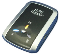
Recommended GPS Logger
RTK GPS can capture accuracy of 2-4 cm at a high refresh rate. Having an RTK GPS, no GCPs are needed to obtain high accuracy.
A list of available loggers is maintained by OpenStreetMap.
For more information about geolocation file formats supported by PIX4Dmapper: Input files.
For more information about how the onboard GPS affects the accuracy of a project: How the onboard GPS affects the project accuracy?.